Category:Hoogstraat 2, Eenrum
Jump to navigation
Jump to search
| Object location | | View all coordinates using: OpenStreetMap |
|---|
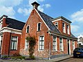
building in De Marne, Netherlands  | |||||
| Upload media | |||||
| Instance of | |||||
|---|---|---|---|---|---|
| Location | Eenrum, Het Hogeland, Groningen, Netherlands | ||||
| Street address |
| ||||
| Located on street |
| ||||
| Heritage designation |
| ||||
 | |||||
|
This is a category about rijksmonument number 14541
|
| Address |
|
Media in category "Hoogstraat 2, Eenrum"
The following 3 files are in this category, out of 3 total.
-
 Eenrum - Hoogstraat 2 (2).jpg 4,000 × 3,000; 4.18 MB
-
 Eenrum - Hoogstraat 2.jpg 3,537 × 2,653; 3.57 MB
-
 Overzicht voorgevels en linker zijgevel - Eenrum - 20364536 - RCE.jpg 1,178 × 1,200; 325 KB
.jpg)
