Category:Hooigracht 27, Leiden
Jump to navigation
Jump to search
| Object location | | View all coordinates using: OpenStreetMap |
|---|
building in Leiden, Netherlands  | |||||
| Upload media | |||||
| Instance of | |||||
|---|---|---|---|---|---|
| Location | Leiden, South Holland, Netherlands | ||||
| Heritage designation |
| ||||
 | |||||
|
This is a category about rijksmonument number 24922
|
| Address |
|
Media in category "Hooigracht 27, Leiden"
The following 18 files are in this category, out of 18 total.
-
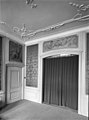 Achterkamer - Leiden - 20136230 - RCE.jpg 890 × 1,200; 166 KB
-
 ErfgoedLeiden LEI001015866 Hooigracht met nr 27.jpg 3,888 × 4,939; 4.1 MB
-
 Gevel - Leiden - 20136231 - RCE.jpg 801 × 1,200; 175 KB
-
 Interieur grauwtjes door G. van Nijmegen - Leiden - 20136218 - RCE.jpg 1,200 × 896; 190 KB
-
 Interieur grauwtjes door G. van Nijmegen - Leiden - 20136219 - RCE.jpg 1,200 × 887; 157 KB
-

-

-
-
 Interieur, plafond - Leiden - 20136223 - RCE.jpg 1,200 × 888; 182 KB
-
 Leiden - Hooigracht 27.JPG 3,056 × 4,592; 3.99 MB
-
 Leiden - Hooigracht 27A.JPG 3,056 × 4,592; 4.78 MB
-
 Omlijste ingangspartij met kuifornament - Leiden - 20364031 - RCE.jpg 1,200 × 1,200; 279 KB
-

-
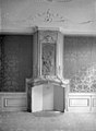
 Schoorsteen achterkamer - Leiden - 20136228 - RCE.jpg 884 × 1,200; 194 KB
-
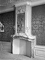
 Schoorsteen achterkamer - Leiden - 20136229 - RCE.jpg 884 × 1,200; 196 KB
-
 Trap - Leiden - 20136224 - RCE.jpg 892 × 1,200; 272 KB
-
 Voorgevel - Leiden - 20136225 - RCE.jpg 814 × 1,200; 231 KB
-


