Category:Hooigracht 42, Leiden
Jump to navigation
Jump to search
| Object location | | View all coordinates using: OpenStreetMap |
|---|
 | |||||
| Upload media | |||||
| Instance of |
| ||||
|---|---|---|---|---|---|
| Location | Leiden, South Holland, Netherlands | ||||
| Heritage designation |
| ||||
 | |||||
|
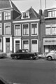
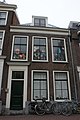
This is a category about rijksmonument number 24949
|
| Address |
|
Media in category "Hooigracht 42, Leiden"
The following 2 files are in this category, out of 2 total.
-
 Gevel - Leiden - 20136253 - RCE.jpg 802 × 1,200; 157 KB
-
 Leiden - Hooigracht 42.JPG 3,056 × 4,592; 3.92 MB
