Category:Hugenottenstraße 66
Jump to navigation
Jump to search
This is the category of the Hessian Kulturdenkmal (cultural monument) with the ID Unknown? (Wikidata)
|
| Object location | | View all coordinates using: OpenStreetMap |
|---|
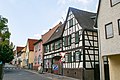
Cultural heritage monument in Friedrichsdorf  | |||||
| Upload media | |||||
| Instance of | |||||
|---|---|---|---|---|---|
| Location | Friedrichsdorf, Hochtaunuskreis, Darmstadt Government Region, Hesse, Germany | ||||
| Street address |
| ||||
| Heritage designation | |||||
 | |||||
Media in category "Hugenottenstraße 66"
The following 4 files are in this category, out of 4 total.
-
 Bad Homburg vor der Höhe 2008-07-30 06.jpg 3,888 × 2,592; 7.93 MB
-
 Bad Homburg, July 2008, 01.jpg 2,592 × 1,944; 3.79 MB
-
 Friedrichsdorf, Hugenottenstraße 66 (1).jpg 4,213 × 4,631; 10.61 MB
-
 Friedrichsdorf, Hugenottenstraße 66.jpg 5,349 × 4,730; 15.4 MB


.jpg)