Category:Huis Teisterbant, Kerkdriel
Jump to navigation
Jump to search
| Object location | | View all coordinates using: OpenStreetMap |
|---|
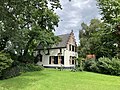
house in Maasdriel, Netherlands  | |||||
| Upload media | |||||
| Instance of | |||||
|---|---|---|---|---|---|
| Location | Kerkdriel, Maasdriel, Gelderland, Netherlands | ||||
| Street address |
| ||||
| Located on street |
| ||||
| Heritage designation |
| ||||
 | |||||
|
This is a category about rijksmonument number 26556
|
| Address |
|
Media in category "Huis Teisterbant, Kerkdriel"
The following 11 files are in this category, out of 11 total.
-
 Het Teisterbant.jpg 2,048 × 1,216; 826 KB
-
 Huis Teisterbant.jpg 4,032 × 3,024; 4.61 MB
-
 Interieur van de zolder - Kerkdriel - 20124612 - RCE.jpg 1,200 × 958; 198 KB
-
 Interieur van de zolder - Kerkdriel - 20124613 - RCE.jpg 958 × 1,200; 186 KB
-
 Interieur, opkamer - Kerkdriel - 20124611 - RCE.jpg 1,200 × 966; 160 KB
-
 Interieur, salon - Kerkdriel - 20124610 - RCE.jpg 1,200 × 949; 183 KB
-
 Linker zijgevel - Kerkdriel - 20124609 - RCE.jpg 1,200 × 965; 212 KB
-
 Rechter zijgevel - Kerkdriel - 20124608 - RCE.jpg 1,200 × 960; 290 KB
-
 Teisterbant.jpg 2,130 × 1,448; 580 KB
-
 Voorgevel - Kerkdriel - 20124607 - RCE.jpg 1,200 × 951; 287 KB
-
 Voorgevel - Kerkdriel - 20124620 - RCE.jpg 801 × 1,200; 187 KB


