Category:Huize De Kolk
Jump to navigation
Jump to search
|
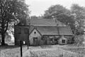
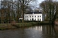
This is a category about a municipal monument in Sint-Oedenrode with number 2 |
| Object location | | View all coordinates using: OpenStreetMap |
|---|
Media in category "Huize De Kolk"
The following 20 files are in this category, out of 20 total.
-
 Andere zijgevel - Sint-Oedenrode - 20170850 - RCE.jpg 1,200 × 807; 307 KB
-
 Interieur, begane grond, hal, vloer, met mozaïk - Sint-Oedenrode - 20001760 - RCE.jpg 1,190 × 1,200; 277 KB
-

-
 Kolk, De-St. Oedenrode (24).JPG 3,008 × 2,000; 6.44 MB
-
 Linker zijgevel met gedeelte achtergevel - Sint-Oedenrode - 20001754 - RCE.jpg 1,192 × 1,200; 383 KB
-
 Overzicht - Sint-Oedenrode - 20001749 - RCE.jpg 1,197 × 1,200; 547 KB
-
 Overzicht - Sint-Oedenrode - 20001750 - RCE.jpg 1,200 × 1,197; 517 KB
-
 Overzicht - Sint-Oedenrode - 20170847 - RCE.jpg 1,200 × 804; 277 KB
-
 Overzicht met "De Kolk" - Sint-Oedenrode - 20001746 - RCE.jpg 1,190 × 1,200; 388 KB
-
 Overzicht met "De Kolk" - Sint-Oedenrode - 20001747 - RCE.jpg 1,190 × 1,200; 437 KB
-
 Overzicht voordeur - Sint-Oedenrode - 20001756 - RCE.jpg 1,200 × 1,190; 367 KB
-
 Overzicht, achterzijde - Sint-Oedenrode - 20001753 - RCE.jpg 1,190 × 1,200; 430 KB
-
 Overzicht, voorgevel - Sint-Oedenrode - 20001751 - RCE.jpg 1,178 × 1,200; 433 KB
-
 Overzicht, voorgevel met linker zijgevel - Sint-Oedenrode - 20001752 - RCE.jpg 1,190 × 1,200; 433 KB
-
 Overzicht, voorgevel met rechter zijgevel - Sint-Oedenrode - 20001748 - RCE.jpg 1,192 × 1,200; 569 KB
-
 Rechter zijgevel met gedeelte voorgevel - Sint-Oedenrode - 20001755 - RCE.jpg 1,190 × 1,200; 436 KB
-
 Voorgevel ? - Sint-Oedenrode - 20170848 - RCE.jpg 1,200 × 816; 326 KB
-
 Voorgevel, jaartalsteen boven voordeur - Sint-Oedenrode - 20001758 - RCE.jpg 1,195 × 1,200; 308 KB
-
 Voorgevel, kozijn, detail - Sint-Oedenrode - 20001757 - RCE.jpg 1,183 × 1,200; 424 KB
-
 Zijgevel - Sint-Oedenrode - 20170849 - RCE.jpg 1,200 × 811; 308 KB


.JPG)


