Category:Humboldt County, Nevada
Jump to navigation
Jump to search
Counties of Nevada: Churchill · Clark · Douglas · Elko · Esmeralda · Eureka · Humboldt · Lander · Lincoln · Lyon · Mineral · Nye · Pershing · Storey · Washoe · White Pine ·Independent city: Carson City
county in Nevada, United States   | |||||
| Upload media | |||||
| Instance of | |||||
|---|---|---|---|---|---|
| Named after | |||||
| Location | Nevada | ||||
| Capital | |||||
| Inception |
| ||||
| Population |
| ||||
| Area |
| ||||
| Different from | |||||
| official website | |||||
 | |||||
English: Media related to Humboldt County, Nevada, a county in northwestern Nevada, United States.
Subcategories
This category has the following 17 subcategories, out of 17 total.
*
B
E
F
H
M
N
P
S
T
Media in category "Humboldt County, Nevada"
The following 62 files are in this category, out of 62 total.
-
 04 15 09 051x - Flickr - drewj1946.jpg 3,872 × 2,592; 1.57 MB
-
 04 15 09 089x - Flickr - drewj1946.jpg 3,498 × 2,476; 2.88 MB
-
 04 15 09 108x - Flickr - drewj1946.jpg 3,820 × 2,544; 5.72 MB
-
 2012, Quinn River Valley, Nevada - panoramio.jpg 4,320 × 3,240; 5.49 MB
-
 2012, View South to Nevada's Quinn River Valley, from Malheur County Oregon - panoramio.jpg 4,320 × 3,240; 5.58 MB
-

-

-

-

-
-

-

-

-

-

-

-
 61 miles to Gerlach.... (3071450561).jpg 3,264 × 2,448; 1.02 MB
-
-

-

-
 Basalt ? (3071450989).jpg 3,264 × 2,448; 1.12 MB
-
 Basalt ? (3071451331).jpg 3,264 × 2,448; 1.14 MB
-
 Cabin-Lahontan Cutthroat Trout Natural Area-Winnemuca District-Scott Moore (24486670253).jpg 4,000 × 3,000; 4.35 MB
-
 Camping-Emigrant Peak-Battle Mountain District-Scott Moore (19984285811).jpg 4,000 × 3,000; 1.87 MB
-
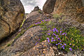
 Disaster Peak and wildflowers.jpg 3,555 × 2,140; 6.38 MB
-
 Disaster Peak Nevada, Blain Davis, Photographer, 2012 - panoramio.jpg 4,320 × 3,240; 4.64 MB
-
 Fall Chokecherries (19978888375).jpg 5,334 × 4,000; 3.35 MB
-
-
-
 Grassland Types - Nevada - DPLA - 594ba66a1bf7825c44e798d79b29cb09.jpg 4,728 × 3,900; 2.39 MB
-
 Hiking-Emigrant Peak-Battle Mountain District-Scott Moore (19971350752).jpg 4,000 × 3,000; 2.07 MB
-
 Humboldt County, NV, USA - panoramio.jpg 640 × 480; 295 KB
-
 IndianPaintbrush-Disaster Peak WSA-Winnemuca District-Scott Moore (19358018133).jpg 4,000 × 3,000; 2.8 MB
-

-
 Looking north at the Jumbo Mine's treatment tanks - panoramio.jpg 2,448 × 3,264; 3.89 MB
-
 Map of Nevada highlighting Humboldt County.svg 809 × 1,196; 26 KB
-
 My Public Lands Roadtrip- Pine Forest Range Wilderness Area (19514482152).jpg 1,200 × 797; 1.18 MB
-
 My Public Lands Roadtrip- Pine Forest Range Wilderness Area (19525351511).jpg 1,200 × 797; 799 KB
-

-
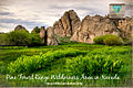
 My Public Lands Roadtrip- Pine Forest Range Wilderness Area in Nevada (18876645333).jpg 3,000 × 1,999; 1.97 MB
-

-
-

-

-
 My Public Lands Roadtrip- Pine Forest Range Wilderness Area in Nevada (19497456635).jpg 2,400 × 1,594; 3.99 MB
-
 Onion Lake Reservoir (19354769604).jpg 1,200 × 800; 398 KB
-

-
 Sawtooth Mine Camp, Humboldt Co., NV - panoramio.jpg 640 × 480; 273 KB
-

-
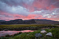 Sky candy (19969732902).jpg 5,760 × 3,840; 20.51 MB
-
 Sulcaria spiralifera 5533840.jpg 1,365 × 2,048; 1.71 MB
-
 Sulcaria spiralifera 5533843.jpg 1,365 × 2,048; 1.83 MB
-
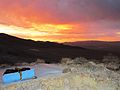
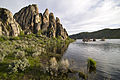
 Sunset Over Blue Lake (12769705335).jpg 2,816 × 2,112; 2.3 MB
-
 The Quinn River Valley, Blain Davis, Photographer, 2012 - panoramio.jpg 4,320 × 3,240; 4.93 MB
-
 The Santa Rosa Range, Nevada, , Blain Davis, Photographer, 2012 - panoramio.jpg 4,320 × 3,240; 5.32 MB
-
 Tiger Swallowtail Butterfly (19984085821).jpg 5,334 × 4,000; 3.46 MB
-
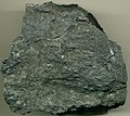 Twin Creeks mine Nevada Carlin-type gold ore.jpg 1,451 × 1,297; 433 KB
-
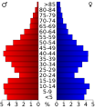 USA Humboldt County, Nevada age pyramid.svg 520 × 600; 7 KB
-
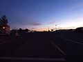
 View N, US 95, McDermitt, NV, 2012 - panoramio.jpg 4,320 × 3,240; 4.98 MB
-
 View S, US 95, McDermitt, NV, 2012 - panoramio.jpg 4,320 × 3,240; 4.04 MB
-
 Vista-Disaster Peak WSA-Winnemuca District-Scott Moore (19792333029).jpg 4,000 × 3,000; 2.48 MB
-


.jpg)

_2_(14739423003).jpg)
.jpg)
.jpg)
.jpg)
.jpg)


.jpg)

.jpg)

.jpg)


.jpg)
.jpg)
.jpg)
.jpg)
.jpg)
.jpg)
.jpg)
.jpg)
.jpg)
.jpg)
.jpg)


.jpg)


.jpg)


.jpg)


.jpg)