Category:Hurley, Warwickshire
Jump to navigation
Jump to search
village in United Kingdom  | |||||
| Upload media | |||||
| Instance of | |||||
|---|---|---|---|---|---|
| Location | Kingsbury, North Warwickshire, Warwickshire, West Midlands, England | ||||
| Different from | |||||
| official website | |||||
 | |||||
English: Hurley is a village in Warwickshire, England. It is located in the North Warwickshire district of the county, close to the village of Kingsbury and is part of the civil parish of its neighbour. Other nearby places include Coleshill, Water Orton, Curdworth, Atherstone and Tamworth.
Subcategories
This category has only the following subcategory.
R
Media in category "Hurley, Warwickshire"
The following 59 files are in this category, out of 59 total.
-
 A view towards Bentley - geograph.org.uk - 108609.jpg 640 × 433; 106 KB
-
 Atherstone House, Hurley - geograph.org.uk - 2564942.jpg 640 × 480; 369 KB
-
 Black cattle near Hurley - geograph.org.uk - 6015330.jpg 5,170 × 3,447; 5.49 MB
-
 Business premises at Hurley Hall Farm - geograph.org.uk - 2560978.jpg 640 × 480; 372 KB
-
 Dingly Dell ^ - geograph.org.uk - 110658.jpg 480 × 640; 180 KB
-
 Farmland south of Hurley - geograph.org.uk - 3168498.jpg 640 × 480; 120 KB
-
 Field entrance near Hurley - geograph.org.uk - 6016038.jpg 6,000 × 4,000; 3.94 MB
-
 Field of stubble near Hurley - geograph.org.uk - 6011993.jpg 6,000 × 4,000; 4.67 MB
-
 Footpath to Hoar Park - geograph.org.uk - 210866.jpg 640 × 480; 61 KB
-
 Footpath to Hurley - geograph.org.uk - 6019192.jpg 6,000 × 4,000; 4.57 MB
-
 Heanley Lane nearing Hurley - geograph.org.uk - 2553118.jpg 640 × 480; 421 KB
-
 House in Hurley - geograph.org.uk - 3168599.jpg 640 × 475; 44 KB
-
 Hurley Cemetery - geograph.org.uk - 1916038.jpg 512 × 640; 574 KB
-
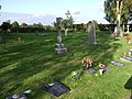 Hurley Cemetery - geograph.org.uk - 3168602.jpg 640 × 480; 101 KB
-
 Hurley Hall - geograph.org.uk - 2558464.jpg 640 × 480; 400 KB
-
 Hurley Hall - geograph.org.uk - 3168513.jpg 640 × 480; 90 KB
-
 Hurley Hall - geograph.org.uk - 6015310.jpg 6,000 × 4,000; 5.05 MB
-
 Hurley Hall Farm on Atherstone Lane - geograph.org.uk - 4842991.jpg 800 × 527; 115 KB
-
 Hurley post office - geograph.org.uk - 108602.jpg 640 × 410; 112 KB
-

-
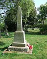
 Hurley War Memorial - geograph.org.uk - 3168607.jpg 640 × 480; 109 KB
-
 Knowle Hill in Hurley - geograph.org.uk - 4842983.jpg 800 × 497; 106 KB
-
 Lane heading north towards Hurley - geograph.org.uk - 3168481.jpg 640 × 480; 128 KB
-
 Lane heading north towards Hurley - geograph.org.uk - 3168504.jpg 640 × 480; 105 KB
-
 Lane south of Hurley - geograph.org.uk - 6015351.jpg 6,000 × 4,000; 5.22 MB
-

-
 Military firing range near Hurley - geograph.org.uk - 6170347.jpg 6,000 × 4,000; 7.51 MB
-
 Moat by Hurley Hall - geograph.org.uk - 6011990.jpg 5,715 × 3,809; 3.87 MB
-
 Play area, Hurley Primary School - geograph.org.uk - 2564941.jpg 640 × 480; 387 KB
-
 Playground, Hurley Primary School - geograph.org.uk - 2564940.jpg 640 × 480; 347 KB
-
 Road Junction outside Hurley Hall - geograph.org.uk - 2730833.jpg 640 × 428; 69 KB
-
 Sheep near Hurley - geograph.org.uk - 6015340.jpg 6,000 × 4,000; 3.83 MB
-
 Snowdrops in Baxterley Churchyard - geograph.org.uk - 111036.jpg 640 × 480; 136 KB
-
 The Holly Bush, Hurley - geograph.org.uk - 5940535.jpg 6,000 × 4,000; 7.72 MB
-
 Waterless Moat next to Baxterley Church - geograph.org.uk - 111037.jpg 640 × 480; 174 KB
-
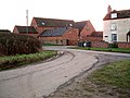
 A very muddy track ^ - geograph.org.uk - 110665.jpg 640 × 480; 122 KB
-
 Brook End Farm - geograph.org.uk - 110661.jpg 640 × 480; 94 KB
-
 Camp Farm, Hurley - geograph.org.uk - 110641.jpg 515 × 640; 100 KB
-
 Cemetery, Heanley Lane, Hurley - geograph.org.uk - 110634.jpg 640 × 480; 106 KB
-
 Cottage near Brook End, near Hurley - geograph.org.uk - 110663.jpg 640 × 480; 83 KB
-

-
 Field of wheat at Hoar Park Farm - geograph.org.uk - 210863.jpg 640 × 480; 64 KB
-
 Fields looking towards Dudley Wood Farm - geograph.org.uk - 111150.jpg 640 × 444; 116 KB
-
 Heanley Lane, Hurley Common - geograph.org.uk - 110618.jpg 640 × 480; 138 KB
-
 Hedgerow near Dudley Wood Farm - geograph.org.uk - 111151.jpg 493 × 640; 128 KB
-
 Hipsley Farm - geograph.org.uk - 111041.jpg 640 × 480; 92 KB
-
 Hoar Park - geograph.org.uk - 103751.jpg 480 × 640; 133 KB
-
 Hoar Park Farm - geograph.org.uk - 210868.jpg 640 × 480; 46 KB
-
 Hurley Farm, Hurley Common - geograph.org.uk - 110623.jpg 640 × 489; 86 KB
-
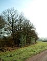
 Ivy clad trees - geograph.org.uk - 111042.jpg 480 × 640; 126 KB
-
 Lane to Kimberley Hall Farm - geograph.org.uk - 111147.jpg 640 × 480; 123 KB
-

-
 Lane to Newland Farm, Bentley - geograph.org.uk - 111157.jpg 480 × 640; 141 KB
-
 Longview, Bentley - geograph.org.uk - 111155.jpg 640 × 476; 114 KB
-
 Military Firing Range - geograph.org.uk - 403340.jpg 640 × 480; 125 KB
-
 The Holly Bush, Hurley - geograph.org.uk - 108603.jpg 640 × 501; 118 KB
-
 The road out of Foul End - geograph.org.uk - 108607.jpg 426 × 640; 91 KB
-
 Tib Hall Farm - geograph.org.uk - 111028.jpg 491 × 640; 107 KB
-
 Tree at sunset, Bentley lanes - geograph.org.uk - 110749.jpg 480 × 640; 97 KB


