Category:Hurricane evacuation route signs in the United States
Jump to navigation
Jump to search
Media in category "Hurricane evacuation route signs in the United States"
The following 23 files are in this category, out of 23 total.
-

-
 2014-08-27 10 58 11 Sign for the Coastal Evacuation Route at the Red Lion Circle.JPG 3,264 × 2,448; 4.32 MB
-

-
 Cairo ice stand at US84 and Broad.jpg 3,264 × 2,448; 2.15 MB
-
 CivilDefenseEvacuationRouteSign-OrmondBeach (38561462700).jpg 1,600 × 2,400; 2.19 MB
-
 East Dublin Water Tower.jpg 5,184 × 3,456; 6.97 MB
-
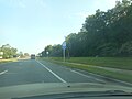
 Evacuation lane (1353394245).jpg 1,600 × 1,200; 1.4 MB
-
 FEMA - 38218 - Hurricane Evacuation Route Road sign in Texas.jpg 2,496 × 2,268; 380 KB
-
 FuracaoVB.JPG 535 × 383; 30 KB
-
 HART Hurricane Emergency Route.JPG 4,000 × 3,000; 2.4 MB
-
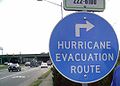
 Hurricane Evacuation Route.jpg 3,072 × 2,304; 1.16 MB
-
 Hurricane evacuation route.jpg 1,820 × 2,237; 1.68 MB
-
 Hurricane Route sign Tulane Avenue floodlines.jpg 1,944 × 2,592; 1.36 MB
-
 MUTCD EM1-1a.svg 198 × 198; 10 KB
-
 NB US 1-WB FL 100; Evacuation Routes.jpg 1,309 × 732; 422 KB
-
 NB US 19-27; Hurricane E-Vac Sign north of Main Street, Perry, FL.jpg 3,648 × 2,736; 2.06 MB
-
 NB US ALT 17 and US 21 enter Hampton County.jpg 3,648 × 2,736; 2 MB
-
 NB US ALT 17 with US 21; Evacuation Route.jpg 3,648 × 2,736; 2.68 MB
-
 SB FL 15A; FL 44 Evacuation Route.jpg 3,648 × 2,736; 2.06 MB
-
 SR79 Hurricane Evaculation Route Sign at Ebro.jpg 2,736 × 1,824; 2.31 MB
-
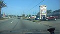
 U.S. 84 westbound at Broad Street in Cairo.jpg 3,264 × 2,448; 2.23 MB
-
 US Route 301 - Maryland (4133811436).jpg 1,024 × 768; 314 KB
-
 US Route 301 - Maryland (4133811978).jpg 1,024 × 768; 305 KB


_between_12th_Street_and_11th_Street_in_Brigantine,_Atlantic_County,_New_Jersey.jpg)

.jpg)

.jpg)


.jpg)
.jpg)