Category:Images by Becky Williamson
Jump to navigation
Jump to search

Media in category "Images by Becky Williamson"
The following 189 files are in this category, out of 189 total.
-
 5 miles to Taunton (geograph 4503202).jpg 480 × 640; 127 KB
-
 All Saints Church, Kingsdon (geograph 4570864).jpg 480 × 640; 74 KB
-
 Allt a'Ghill, Taransay - geograph.org.uk - 1756733.jpg 426 × 640; 103 KB
-
 Ancient wall near Beinn Dubh, Islay - geograph.org.uk - 1750257.jpg 426 × 640; 104 KB
-
 Arable fields south of West Compton (geograph 4848795).jpg 640 × 427; 67 KB
-
 Ardmore Trigpoint, Islay - geograph.org.uk - 1749971.jpg 567 × 378; 163 KB
-
 Auldearn Church (geograph 1863079).jpg 640 × 427; 69 KB
-
 Ballivicar Farmhouse, Islay - geograph.org.uk - 1757844.jpg 640 × 426; 67 KB
-
 Ballychatrigan Farm, Islay - geograph.org.uk - 1757872.jpg 640 × 426; 59 KB
-
 Beach at Ardtalla, Islay (geograph 2414069).jpg 640 × 411; 48 KB
-
 Bealach Clithe, Cleadale, Eigg - geograph.org.uk - 1761617.jpg 640 × 426; 87 KB
-
 Becky on trig, Beinn Sholum, Islay - geograph.org.uk - 1741646.jpg 640 × 427; 59 KB
-
 Benchmark on mileopst, A30, west of Sherborne (geograph 5322071).jpg 640 × 427; 95 KB
-

-
 Benchmark on St Marys Church, Shapwick (geograph 4610703).jpg 640 × 480; 113 KB
-
 Benchmark on St Michaels Church, Cudworth (geograph 5342842).jpg 640 × 427; 113 KB
-
 Benchmark on St Michaels Church, West Compton (geograph 4848815).jpg 640 × 427; 97 KB
-

-
 Benchmark, Windsor Hotel, Weymouth (geograph 4337002).jpg 640 × 427; 59 KB
-
 Bond Street Toilets, Weymouth (geograph 4408822).jpg 480 × 640; 56 KB
-

-
 BT exchange near Laphroaig, Islay - geograph.org.uk - 1741823.jpg 640 × 427; 61 KB
-
 Bun na h-Aibhne, near Kilchiaran, Islay - geograph.org.uk - 1750512.jpg 640 × 426; 102 KB
-
 Burntisland Town Hall (geograph 6121061).jpg 640 × 427; 52 KB
-
 Cadzow Bridge, Hamilton - geograph.org.uk - 2275723.jpg 640 × 480; 41 KB
-
 Carnbuie, near Bowmore, Islay - geograph.org.uk - 1763470.jpg 640 × 427; 117 KB
-
 Carnbuie, near Bowmore, Islay - geograph.org.uk - 1763476.jpg 640 × 427; 126 KB
-
 Carnbuie, near Bowmore, Islay - geograph.org.uk - 1763483.jpg 640 × 427; 90 KB
-
 Carnbuie, near Bowmore, Islay - geograph.org.uk - 1763488.jpg 640 × 427; 63 KB
-
 Celtic cross Canna Geograph-1761616-by-Becky-Williamson.jpg 454 × 640; 102 KB
-
 Chapel, Nave Island, Islay (geograph 4150317).jpg 640 × 426; 76 KB
-
 Church of St John the Baptist, Glastonbury (geograph 4305231).jpg 640 × 480; 54 KB
-
-
 Church of St Mary the Virgin, Powerstock (geograph 4890332).jpg 640 × 427; 91 KB
-
 Clach an Teampuill - geograph.org.uk - 1756759.jpg 426 × 640; 76 KB
-
 Clach Biorach, Taransay - geograph.org.uk - 1756987.jpg 640 × 426; 71 KB
-
 Clett Agrapaidh, Taransay - geograph.org.uk - 1756984.jpg 640 × 426; 106 KB
-
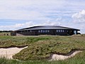 Clubhouse, The Castle Golf Course (geograph 6152558).jpg 640 × 480; 62 KB
-
 Cnoc nan Caorach from the west - geograph.org.uk - 1763495.jpg 640 × 427; 69 KB
-
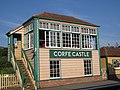 Corfe Castle Station (geograph 5087895).jpg 640 × 480; 76 KB
-
 Covenanters Grave, Auldearn (geograph 1863060).jpg 640 × 427; 94 KB
-
 St Michaels Church, Cudworth (geograph 5342831).jpg 640 × 427; 58 KB
-
 Cullipool Village, Isle of Luing - geograph.org.uk - 1758733.jpg 567 × 295; 67 KB
-
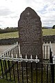 Dalmore Conventicle Stone, Alness (geograph 1864555).jpg 427 × 640; 75 KB
-
 Deck chairs on The Esplanade, Weymouth (geograph 4557233).jpg 480 × 640; 86 KB
-

-
 Dovecot at Boarhills (geograph 6152554).jpg 640 × 480; 83 KB
-
 Dovecot Gateway to Balcaskie House (geograph 6315103).jpg 640 × 427; 78 KB
-
 Dreel Halls, Anstruther Wester (geograph 6315107).jpg 640 × 427; 65 KB
-
 Dun an Oir, Cleire (geograph 2612642).jpg 480 × 640; 71 KB
-
 Dun Mor Broch, Vaul, Tiree - geograph.org.uk - 3658004.jpg 640 × 480; 87 KB
-
 Dun Mor Broch, Vaul, Tiree - geograph.org.uk - 3659481.jpg 640 × 480; 81 KB
-

-
 Duns, near Beinn Dubh, Islay - geograph.org.uk - 1750251.jpg 640 × 426; 60 KB
-
 Dùn, near Paible, Taransay - geograph.org.uk - 1755401.jpg 640 × 426; 67 KB
-

-
 East Cliff, West Bay, Dorset-geograph-5064992.jpg 480 × 640; 77 KB
-
 Eilean Coinnich, Islay - geograph.org.uk - 1761431.jpg 640 × 426; 70 KB
-

-
 Finns Pub, Great George St, Weymouth (geograph 4557239).jpg 640 × 480; 81 KB
-

-

-
 Former school, Portnahaven, Islay (geograph 4208854).jpg 427 × 640; 80 KB
-

-
 Giant's footprint, near Laig, Eigg - geograph.org.uk - 1760250.jpg 800 × 525; 136 KB
-

-
 Giùr-bheinn from Beinn Bhreac, Islay - geograph.org.uk - 1740508.jpg 640 × 427; 80 KB
-
 Gortan School House, Islay (geograph 4253477).jpg 640 × 480; 75 KB
-
 Gortantoid Farm - geograph.org.uk - 1740489.jpg 640 × 426; 81 KB
-
 Gortantoid Farm, Islay - geograph.org.uk - 1740493.jpg 640 × 426; 65 KB
-
 Gortantoid from east - geograph.org.uk - 1740486.jpg 640 × 427; 70 KB
-

-
 Grave of Rev. Thomas Hog, Kiltearn (geograph 1863723).jpg 427 × 640; 69 KB
-
 Grave, Aird nan Uan, Muck - geograph.org.uk - 1760245.jpg 640 × 426; 85 KB
-
 Grave, Aird nan Uan, Muck - geograph.org.uk - 1760246.jpg 640 × 426; 88 KB
-
 Grave, Aird nan Uan, Muck - geograph.org.uk - 1760247.jpg 640 × 426; 92 KB
-
 Graves, Aird nan Uan, Muck - geograph.org.uk - 1760248.jpg 1,024 × 491; 109 KB
-
 Green Hill trig point (geograph 4810587).jpg 640 × 427; 49 KB
-
 Grianan-Geograph-2948228-by-Becky-Williamson.jpg 640 × 457; 67 KB
-
 Grounds at Mappercombe Manor (geograph 4890335).jpg 640 × 427; 61 KB
-
 Harper's Barn, Marshwood, Dorset (geograph 5493860).jpg 640 × 479; 65 KB
-
 Herrison House, Charlton Down (geograph 5721573).jpg 640 × 427; 53 KB
-
 Houses in the village of Sutton Poyntz (geograph 4337111).jpg 640 × 427; 105 KB
-
 Hut Circle, Na Leacan, Islay - geograph.org.uk - 1750014.jpg 567 × 378; 248 KB
-
 Ineraval, Islay - geograph.org.uk - 1757862.jpg 640 × 426; 61 KB
-
 Islay House, Bridgend, Islay (geograph 2414116).jpg 640 × 480; 76 KB
-
 James Ure's grave, Old graveyard, Kippen - geograph.org.uk - 1750424.jpg 427 × 640; 105 KB
-
 John on trig, Beinn Airein, Muck - geograph.org.uk - 1741626.jpg 640 × 427; 52 KB
-
 Kildonan Lodge, Isle of Eigg (geograph 3091726).jpg 640 × 427; 66 KB
-
 Kintour Chapel, Islay - geograph.org.uk - 1749173.jpg 1,600 × 1,067; 381 KB
-
 Kintour Chapel, Islay - geograph.org.uk - 1749177.jpg 1,600 × 1,067; 455 KB
-
 Leslie Coat of Arms, Balgonie Castle (geograph 2667920).jpg 480 × 640; 102 KB
-

-
 Limekiln, East Lomond (geograph 7416904).jpg 640 × 427; 53 KB
-

-
 Loch Carn a Mhaoil, Islay (geograph 3134678).jpg 640 × 320; 47 KB
-
 Loch na Beinne, Islay - geograph.org.uk - 1804126.jpg 640 × 426; 53 KB
-
 Loch Poit na h-I, Mull (geograph 3993105).jpg 640 × 480; 54 KB
-
 Loch Starabraigh, Taransay - geograph.org.uk - 1756980.jpg 640 × 426; 38 KB
-
 Lodmoor Nature Reserve, Weymouth (geograph 4323847).jpg 640 × 480; 55 KB
-
 Longformacus House (geograph 2359689).jpg 640 × 480; 116 KB
-
 Mappercombe Manor, Dorset-geograph-4890353.jpg 640 × 427; 70 KB
-
 Marsh and Tallant Plantation, Islay - geograph.org.uk - 1763544.jpg 640 × 427; 46 KB
-

-
 Martyrs Memorial, Gallows Hill, Dorchester (geograph 4320022).jpg 640 × 480; 128 KB
-

-
 Milepost, A30, west of Sherborne (geograph 5322072).jpg 427 × 640; 107 KB
-
 Milestone and benchmark near Thornford (geograph 4323852).jpg 480 × 640; 152 KB
-

-
 Milestone near Hazel Farm on A37 (geograph 4317905).jpg 427 × 640; 131 KB
-
 Milestone, Broadwindsor (geograph 4223744).jpg 480 × 640; 99 KB
-
 Mulindry Bridge, Islay - geograph.org.uk - 4365260.jpg 640 × 480; 119 KB
-
 Natural Arch, Port nan Gallan, Islay - geograph.org.uk - 1749445.jpg 426 × 640; 54 KB
-
 Natural dyke near Beinn Dubh, Islay - geograph.org.uk - 1750260.jpg 640 × 426; 60 KB
-
 New Bridge over the River Ore (geograph 6340167).jpg 640 × 427; 122 KB
-

-
 Old Chapel, The Oa, Islay - geograph.org.uk - 1758728.jpg 567 × 425; 100 KB
-
 Old graveyard, Kippen - geograph.org.uk - 1750416.jpg 640 × 426; 60 KB
-
 Old Mill, Allt na Muilne,Taransay - geograph.org.uk - 1754437.jpg 640 × 426; 134 KB
-
 Old Rooms Inn, Weymouth (geograph 4408862).jpg 640 × 480; 76 KB
-
 Old Shielings near Bochdag, Taransay - geograph.org.uk - 1756743.jpg 640 × 426; 56 KB
-
 Old Town Pump, Weymouth (geograph 4408888).jpg 480 × 640; 84 KB
-
 Paible, Taransay - geograph.org.uk - 1756720.jpg 640 × 426; 69 KB
-
 Part of ancient settlement at Ringmoor (geograph 4864894).jpg 640 × 427; 48 KB
-
-
 Peekie Standing Stone (geograph 7080830).jpg 640 × 480; 31 KB
-
 Phone Kiosk and Information Board, Isle of Kerrerra - geograph.org.uk - 1746882.jpg 1,600 × 1,200; 488 KB
-
 Pillar at Alexandra Gardens, Weymouth (geograph 4557844).jpg 480 × 640; 81 KB
-
 Plague Village, Solam - geograph.org.uk - 1741765.jpg 426 × 640; 61 KB
-
 Plague Village, Solam, Islay - geograph.org.uk - 1741770.jpg 640 × 427; 65 KB
-
 Plaque at plague village, Solam, Islay - geograph.org.uk - 1741775.jpg 640 × 427; 162 KB
-
 Plaque on the Wishart Arch, Dundee (geograph 2176447).jpg 640 × 471; 44 KB
-

-

-
 Port Charlotte Lighthouse, Islay - geograph.org.uk - 1806422.jpg 640 × 480; 51 KB
-
 Pound Cottage, Pound - geograph.org.uk - 4496280.jpg 640 × 480; 123 KB
-
 Powerstock C of E Primary School (geograph 4889205).jpg 640 × 427; 52 KB
-

-
 Remains of a milestone, near Odcombe (geograph 4589519).jpg 480 × 640; 141 KB
-
 Road to Ireland, Orkney (geograph 1990596).jpg 434 × 640; 42 KB
-
 Robert Blairs Grave, St Fillans, Aberdour (geograph 2658865).jpg 640 × 480; 95 KB
-
 Rodwell Station (geograph 5701849).jpg 640 × 427; 113 KB
-
 Rubh a Mhail Lighthouse, Islay (geograph 2414229).jpg 480 × 640; 58 KB
-
 Ruin near Carnbuie, Islay - geograph.org.uk - 1763505.jpg 640 × 427; 119 KB
-
 Ruin, Carnbuie, Islay - geograph.org.uk - 1763516.jpg 640 × 427; 93 KB
-
 Ruins, Paible, Taransay - geograph.org.uk - 1755403.jpg 640 × 377; 46 KB
-

-
 School near Borgh, Barra (geograph 2948274).jpg 640 × 427; 54 KB
-

-
 Scratch dial, St Stephens Church, Winsham (geograph 4372763).jpg 480 × 640; 129 KB
-
 Scratch dial, St Stephens Church, Winsham (geograph 4372764).jpg 640 × 480; 122 KB
-
 Shelter on the Esplanade, Weymouth (geograph 4408882).jpg 640 × 480; 58 KB
-

-
 St Catherine's by the Sea, Holworth, Dorset.jpg 640 × 480; 71 KB
-
 St Edwards Centre, Sanday (geograph 3089989).jpg 640 × 427; 42 KB
-
 St Marys Church, Bradford Peverell (geograph 5676254).jpg 640 × 427; 64 KB
-
 St Michaels Church, West Compton (geograph 4849655).jpg 640 × 427; 60 KB
-
 St Ninian's Chapel, Sanda geograph-1807225-by-Becky-Williamson.jpg 640 × 261; 45 KB
-

-
 Streamer Field, Tallant Farm, Islay - geograph.org.uk - 1763533.jpg 640 × 427; 48 KB
-
 Tarn Hows Cottage, Cumbria-geograph-2279691.jpg 640 × 480; 89 KB
-

-
 The Church of St Roch, Pendomer (geograph 4328185).jpg 640 × 480; 74 KB
-
 The gate to Beinn Bhreac, Islay - geograph.org.uk - 1740473.jpg 640 × 427; 85 KB
-
 The Glebe hostel, Eigg - geograph.org.uk - 1761618.jpg 640 × 427; 48 KB
-
 Thomas Coke's house, South Petherton - geograph.org.uk - 4496204.jpg 640 × 480; 101 KB
-
 Town Hall, Glastonbury (geograph 4305242).jpg 640 × 480; 62 KB
-
 Track near Lagavulin, Islay - geograph.org.uk - 1758080.jpg 640 × 426; 63 KB
-
 Track near Lower Coillabus, Islay - geograph.org.uk - 1758069.jpg 640 × 426; 60 KB
-

-
 Tree at Tallant Farm - geograph.org.uk - 1763546.jpg 427 × 640; 123 KB
-

-
 Trig point, Beinn Dubh, Islay - geograph.org.uk - 1750262.jpg 640 × 426; 62 KB
-
 Trig point, Beinn Rà, Taransay - geograph.org.uk - 1755400.jpg 640 × 426; 74 KB
-
 Trigpoint, Carn nan Gillean, Islay - geograph.org.uk - 1760544.jpg 640 × 426; 56 KB
-
 Trigpoint, Cnoc an Lomair, - geograph.org.uk - 1761466.jpg 640 × 426; 71 KB
-
 Tràigh a Siar, Taransay - geograph.org.uk - 1756978.jpg 640 × 426; 40 KB
-
 Uidhe Bothy, Taransay - geograph.org.uk - 1756755.jpg 640 × 426; 63 KB
-
 Vestra Fiold-Geograph-1991175-by-Becky-Williamson.jpg 640 × 377; 43 KB
-
 View NE from Beinn Bhreac - geograph.org.uk - 1740468.jpg 640 × 427; 77 KB
-
 View NNE from Beinn Bhreac - geograph.org.uk - 1740465.jpg 640 × 427; 65 KB
-
 Waterfall at Lower Killeyan, Islay - geograph.org.uk - 1746921.jpg 1,526 × 1,600; 531 KB
-
 West Compton Manor from the south (geograph 5721921).jpg 640 × 427; 76 KB
-
 West face of Beinn Bhreac, Islay - geograph.org.uk - 1740197.jpg 640 × 427; 51 KB
-
 Weymouth (geograph 5701840).jpg 640 × 427; 54 KB
-
 Weymouth Bay (geograph 4323863).jpg 640 × 480; 88 KB
-
 Weymouth Bay (geograph 4337145).jpg 640 × 427; 48 KB
-
 Weymouth Harbour (geograph 4408886).jpg 640 × 480; 67 KB
-
 Windsor Hotel, Weymouth (geograph 4337005).jpg 640 × 427; 64 KB
.jpg)
.jpg)


.jpg)

.jpg)


.jpg)


.jpg)
.jpg)
.jpg)
.jpg)
.jpg)
.jpg)
.jpg)
.jpg)


.jpg)


.jpg)
.jpg)
.jpg)
.jpg)


.jpg)

.jpg)
.jpg)
.jpg)

.jpg)
.jpg)
.jpg)
.jpg)
.jpg)
.jpg)
.jpg)


_near_Beinn_Dubh,_Islay_-_geograph.org.uk_-_1750248.jpg)


.jpg)
.jpg)
.jpg)
.jpg)
.jpg)


.jpg)


.jpg)


.jpg)

.jpg)
.jpg)
.jpg)
.jpg)


.jpg)


.jpg)


.jpg)
.jpg)
.jpg)

.jpg)

.jpg)

.jpg)
.jpg)


.jpg)

.jpg)
.jpg)

.jpg)
.jpg)


.jpg)
.jpg)


.jpg)

.jpg)

.jpg)
.jpg)
.jpg)

.jpg)


.jpg)

.jpg)


.jpg)
.jpg)
.jpg)
.jpg)
.jpg)
.jpg)
.jpg)


.jpg)
.jpg)
.jpg)
.jpg)
.jpg)
.jpg)
.jpg)

.jpg)
.jpg)
.jpg)


.jpg)


.jpg)


_,_Kerrera,_looking_south_-_geograph.org.uk_-_1746871.jpg)


.jpg)

.jpg)
.jpg)
.jpg)
.jpg)
.jpg)