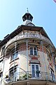
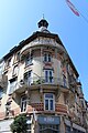
Category:Immeuble, 24 rue Brûlée, Strasbourg
Jump to navigation
Jump to search
| Object location | | View all coordinates using: OpenStreetMap |
|---|
Pour l'histoire du bâtiment, voir Immeuble, 24 rue Brûlée, Strasbourg
Media in category "Immeuble, 24 rue Brûlée, Strasbourg"
The following 5 files are in this category, out of 5 total.
-
 Immeuble 24 rue Brûlée Strasbourg 1.jpg 3,221 × 5,775; 17.6 MB
-
 Immeuble 24 rue Brûlée Strasbourg 2.jpg 3,456 × 5,184; 5.61 MB
-
 Immeuble 24 rue Brûlée Strasbourg 3.jpg 5,074 × 6,270; 27.91 MB
-
 Immeuble 24 rue Brûlée Strasbourg 4.jpg 3,456 × 5,184; 6.55 MB
-
 Immeuble 24 rue Brûlée Strasbourg 5.jpg 3,456 × 5,184; 7.11 MB


