Category:Innerfeldtal
Jump to navigation
Jump to search
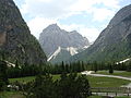
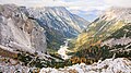
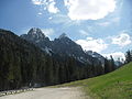
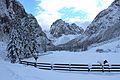
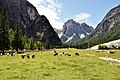
Deutsch: Das Innerfeldtal ( ital. Val Campo di Dentro) ist ein kleines, vom Sextental unweit des Stausees des Sextener Baches (ital. Rio Sesto) nach Süden abzweigendes, nicht offen einsehbares, langgezogenes, sichelförmiges Seitental im östlichsten Teil von Südtirol. Es gehört zu der Gemeinde Innichen.
Italiano: Val Campo di Dentro, San Candido, Alto Adige, Italia.
valley in South Tyrol, Italy  | |||||
| Upload media | |||||
| Instance of | |||||
|---|---|---|---|---|---|
| Location | South Tyrol, Trentino-South Tyrol, Italy | ||||
 | |||||
Subcategories
This category has the following 2 subcategories, out of 2 total.
D
- Dreischusterhütte (5 F)
I
- Innerfeldtal Kapelle (5 F)
Media in category "Innerfeldtal"
The following 18 files are in this category, out of 18 total.
-
 2-8 Stage 1-6 San Candido - Rifugio Antonio Locatelli (Dreizinnenhütte) - panoramio (2).jpg 4,608 × 2,592; 4.95 MB
-
 2-8 Stage 1-6 San Candido - Rifugio Antonio Locatelli (Dreizinnenhütte) - panoramio (7).jpg 4,608 × 2,592; 3.08 MB
-
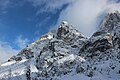
 2010 Sextener Dolomiten 008 Morgenkopf 2493.jpg 3,264 × 2,448; 2.85 MB
-
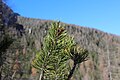 Bergkiefer (Pinus mugo).JPG 5,184 × 3,456; 5.39 MB
-
 Gsellknoten.JPG 5,184 × 3,456; 8.08 MB
-
 Innerfeldtal 1.jpg 3,000 × 4,000; 1.61 MB
-
 Innerfeldtal 2.jpg 4,000 × 3,000; 2.31 MB
-
 Innerfeldtal 3.jpg 4,000 × 3,000; 2.38 MB
-
 Innerfeldtal 4.jpg 3,000 × 4,000; 3.94 MB
-
 Innerfeldtal 5.jpg 4,000 × 3,000; 2.95 MB
-
 Innerfeldtal beim Abstieg vom Toblinger Knoten.jpg 3,840 × 2,160; 4.75 MB
-
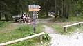
 Innerfeldtal Parkplatz.JPG 4,000 × 3,000; 2.78 MB
-
 Morgenkopf Innerfeldtal.JPG 5,184 × 3,456; 11.16 MB
-
 Panorama dalla Val Campo di Dentro 2.jpg 6,046 × 3,388; 8.23 MB
-
 Panorama dalla Val Campo di Dentro 3.jpg 3,327 × 2,961; 3.69 MB
-
 Panorama dalla Val Campo di Dentro.JPG 3,264 × 2,448; 3.36 MB
-
 Ponticello di legno in Val Campo di Dentro.JPG 3,264 × 2,448; 3.66 MB
-
 Valle campo di dentro.jpg 3,216 × 2,136; 3.77 MB
_-_panoramio_(2).jpg)
_-_panoramio_(7).jpg)

.JPG)


