Category:Inverkeithing (civil parish)
Jump to navigation
Jump to search
Scottish parish in Fife, Scotland, UK | |||||
| Upload media | |||||
| Instance of | |||||
|---|---|---|---|---|---|
| Part of |
| ||||
| Named after | |||||
| Location |
| ||||
| Population |
| ||||
| Area |
| ||||
 | |||||
Subcategories
This category has the following 3 subcategories, out of 3 total.
Media in category "Inverkeithing (civil parish)"
The following 200 files are in this category, out of 823 total.
(previous page) (next page)-
 'HMS Queen Elizabeth' and a Forth bridge - geograph.org.uk - 5442383.jpg 3,264 × 2,448; 2.93 MB
-
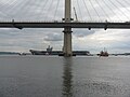 'HMS Queen Elizabeth' and The Queensferry Crossing - geograph.org.uk - 5442374.jpg 3,264 × 2,448; 3.4 MB
-
 'HMS Queen Elizabeth' at Rosyth - geograph.org.uk - 5442324.jpg 3,264 × 2,448; 1.84 MB
-
 'HMS Queen Elizabeth' at Rosyth - geograph.org.uk - 5442339.jpg 3,264 × 2,448; 3.31 MB
-
 'HMS Queen Elizabeth' in the Firth of Forth - geograph.org.uk - 5442311.jpg 3,099 × 2,017; 1.36 MB
-
 'My, your rear looks big from here^' - geograph.org.uk - 5100447.jpg 2,047 × 1,529; 994 KB
-

-
 A bend in the B981 - geograph.org.uk - 3539562.jpg 640 × 480; 67 KB
-
 A Bit of TLC - geograph.org.uk - 2865395.jpg 640 × 425; 99 KB
-
 A glimpse of the Forth Bridge from the B981 - geograph.org.uk - 2823063.jpg 1,024 × 768; 191 KB
-
 A glimpse of the two Forth bridges - geograph.org.uk - 6397555.jpg 658 × 800; 193 KB
-
 A house on Main Street (B981), North Queensferry - geograph.org.uk - 3485437.jpg 1,824 × 1,368; 663 KB
-
 A red red rocket bob bob bobbing up Arthur's Seat - geograph.org.uk - 5508846.jpg 4,000 × 2,248; 2.13 MB
-

-
 A90 at Ferrytoll - geograph.org.uk - 4399603.jpg 640 × 425; 100 KB
-
 A90 heading south - geograph.org.uk - 3539667.jpg 640 × 480; 54 KB
-
 A90 in North Queensferry - geograph.org.uk - 2497882.jpg 3,474 × 2,507; 1.2 MB
-
 A90 Nearing the Bridge - geograph.org.uk - 2675075.jpg 640 × 480; 198 KB
-
 A90 road bridge - geograph.org.uk - 3539663.jpg 640 × 480; 59 KB
-
 A90 Underpass - geograph.org.uk - 2865367.jpg 640 × 425; 97 KB
-
 Abandoned Inspection Cradles - geograph.org.uk - 4399655.jpg 640 × 425; 100 KB
-
 Abandoned pier - geograph.org.uk - 2876838.jpg 2,048 × 1,536; 1.42 MB
-
 Abandoned Road - geograph.org.uk - 2988650.jpg 640 × 425; 98 KB
-
 Access Track - geograph.org.uk - 2988628.jpg 640 × 425; 99 KB
-
 Agricultural Landscape - geograph.org.uk - 2865323.jpg 640 × 425; 97 KB
-
 Albert Hotel - geograph.org.uk - 2831776.jpg 1,536 × 2,048; 940 KB
-
 Albert Hotel North Queensferry - geograph.org.uk - 2794806.jpg 800 × 534; 283 KB
-
 Albert Hotel, North Queensferry - geograph.org.uk - 5454309.jpg 1,024 × 768; 213 KB
-
 Alighting at Inverkeithing - geograph.org.uk - 3005802.jpg 1,200 × 900; 209 KB
-
 Alma Street - geograph.org.uk - 4793675.jpg 640 × 420; 164 KB
-
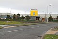
 Amazon warehouse - geograph.org.uk - 5434591.jpg 3,264 × 2,448; 4.24 MB
-
 Amazon Way Dunfermline - geograph.org.uk - 3780903.jpg 640 × 427; 110 KB
-
 Amazon.co.uk warehouse, Dunfermline - geograph.org.uk - 4531563.jpg 1,024 × 682; 170 KB
-
 Anchor on the Town Pier, North Queensferry - geograph.org.uk - 4331617.jpg 3,264 × 2,448; 3.14 MB
-
 Anchor on the Town Quay - geograph.org.uk - 5986630.jpg 640 × 480; 86 KB
-

-
 Approaching Inverkeithing Station - geograph.org.uk - 2486164.jpg 640 × 473; 151 KB
-
 Approaching the Forth Bridge, 1968 - geograph.org.uk - 3308616.jpg 640 × 293; 40 KB
-
 Arthur's Seat from Inverkeithing - geograph.org.uk - 4782853.jpg 640 × 276; 51 KB
-
 B981 heading south - geograph.org.uk - 3539576.jpg 640 × 480; 60 KB
-
 B981 heading to Crossgates - geograph.org.uk - 1825751.jpg 640 × 480; 38 KB
-
 B981 heading towards Inverkeithing - geograph.org.uk - 3539557.jpg 640 × 480; 60 KB
-
 B981 Hope Street at Inverkeithing - geograph.org.uk - 6402480.jpg 800 × 548; 124 KB
-
 B981 Hope Street at Inverkeithing - geograph.org.uk - 6402536.jpg 800 × 627; 161 KB
-
 Ballast Bank - geograph.org.uk - 4791781.jpg 640 × 480; 159 KB
-
 Ballast Bank sports pavilion, Inverkeithing - geograph.org.uk - 2928833.jpg 3,264 × 2,448; 3.55 MB
-
 Bank Street Inverkeithing - geograph.org.uk - 4779197.jpg 640 × 372; 123 KB
-
 Bannerman Avenue - geograph.org.uk - 4793695.jpg 640 × 480; 144 KB
-
 Battery Road North Queensferry - geograph.org.uk - 2794819.jpg 800 × 534; 276 KB
-
 Battery Road North Queensferry - geograph.org.uk - 2794828.jpg 800 × 534; 317 KB
-
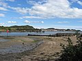
 Beach at North Queensferry - geograph.org.uk - 6398638.jpg 800 × 564; 127 KB
-
 Beach at West Ness - geograph.org.uk - 6392228.jpg 800 × 557; 109 KB
-
 Beehives at Inverkeithing - geograph.org.uk - 3916295.jpg 3,264 × 2,448; 4.01 MB
-
 Beneath the Forth Road Bridge, North Queensferry - geograph.org.uk - 3485376.jpg 2,736 × 3,648; 1.68 MB
-
 Boreland Road at Church Street - geograph.org.uk - 4774403.jpg 640 × 389; 139 KB
-
 Branch line - geograph.org.uk - 3768249.jpg 1,600 × 1,200; 1.3 MB
-
 Bridge beyond Deep Sea - geograph.org.uk - 2876827.jpg 2,048 × 1,536; 825 KB
-
 Bridge over M90 - geograph.org.uk - 6167981.jpg 1,024 × 576; 78 KB
-
 Bridge over the Keithing Burn - geograph.org.uk - 3356655.jpg 640 × 425; 99 KB
-
 Bridge Parapet - geograph.org.uk - 2865339.jpg 640 × 425; 96 KB
-
 Bridge, Gone - geograph.org.uk - 4870233.jpg 640 × 425; 100 KB
-
 British Kestrel at Hound Point oil terminal - geograph.org.uk - 5100424.jpg 2,206 × 1,648; 1.13 MB
-
 Building Bridges - geograph.org.uk - 3970207.jpg 640 × 425; 98 KB
-
 Building on Church Street - geograph.org.uk - 4793688.jpg 640 × 332; 138 KB
-
 Burgh Arms sign - geograph.org.uk - 4779213.jpg 438 × 640; 123 KB
-
 Burgh Arms sign and date stone - geograph.org.uk - 4779206.jpg 640 × 589; 161 KB
-

-
 Burnside Industrial Estate - geograph.org.uk - 2863363.jpg 640 × 409; 96 KB
-
 Bus stop at Hillend - geograph.org.uk - 3916207.jpg 3,264 × 2,448; 3.74 MB
-
 Cafe on High Street - geograph.org.uk - 3539644.jpg 608 × 640; 66 KB
-
 Cairn next to the Fife Coastal Path - geograph.org.uk - 6404043.jpg 800 × 471; 107 KB
-
 Cairn next to the Fife Coastal Path - geograph.org.uk - 6404053.jpg 800 × 526; 150 KB
-
 Car park and A90 - geograph.org.uk - 3438164.jpg 640 × 480; 257 KB
-
 Carlingnose Jetty - geograph.org.uk - 2584097.jpg 2,816 × 2,112; 1.29 MB
-

-
 Carlingnose submarine mining pier - geograph.org.uk - 2581487.jpg 4,320 × 3,240; 2.22 MB
-

-
 Cattle at Annfield - geograph.org.uk - 5593279.jpg 3,264 × 2,448; 3.74 MB
-
 Chapel Place - geograph.org.uk - 4793696.jpg 640 × 480; 165 KB
-
 Church Street - geograph.org.uk - 4774419.jpg 640 × 394; 145 KB
-
 Church Street shops - geograph.org.uk - 4793685.jpg 640 × 480; 148 KB
-
 Civic Centre - geograph.org.uk - 2877058.jpg 2,048 × 1,536; 782 KB
-
 Clockluine Road (B916) - geograph.org.uk - 3539581.jpg 640 × 480; 83 KB
-
 Clockluine Road Cyclepath - geograph.org.uk - 2988665.jpg 640 × 425; 99 KB
-
 Coastal Fife , North Queensferry and Carlingnose Point - geograph.org.uk - 3519502.jpg 1,600 × 1,200; 389 KB
-
 Comfort Store - geograph.org.uk - 3409692.jpg 1,600 × 988; 186 KB
-
 Commemorative plaque for Queen Victoria's Diamond Jubilee - geograph.org.uk - 3521021.jpg 2,616 × 1,335; 1.64 MB
-
 Commercial Road - geograph.org.uk - 4793666.jpg 601 × 640; 155 KB
-
 Commercial Road - geograph.org.uk - 4793669.jpg 640 × 480; 137 KB
-
 Community Centre North Queensferry - geograph.org.uk - 2794914.jpg 800 × 534; 224 KB
-
 Concorde Way, Inverkeithing - geograph.org.uk - 2928850.jpg 3,264 × 2,448; 3.3 MB
-
 Concorde Way, Inverkeithing - geograph.org.uk - 2928858.jpg 3,264 × 2,448; 3.9 MB
-

-
 Construction site, Halbeath - geograph.org.uk - 6130116.jpg 4,513 × 2,393; 2.44 MB
-

-
 Contact Surface - geograph.org.uk - 2348551.jpg 640 × 427; 509 KB
-

-

-
 Cottage at Annfield - geograph.org.uk - 5593284.jpg 3,264 × 2,448; 4.15 MB
-
 Covered reservoir, Ferry Hills - geograph.org.uk - 6319179.jpg 1,024 × 683; 271 KB
-
 Covered reservoir, Inverkeithing - geograph.org.uk - 6538024.jpg 1,024 × 768; 340 KB
-
 Crop field beside the A921 - geograph.org.uk - 3539607.jpg 640 × 480; 62 KB
-
 Crop field near Hillend - geograph.org.uk - 3609196.jpg 640 × 559; 68 KB
-
 Crop field off the B981 - geograph.org.uk - 3539560.jpg 640 × 480; 65 KB
-
 Crop field, Balbougie - geograph.org.uk - 3539589.jpg 640 × 480; 72 KB
-
 Crossing the Forth Bridge at North Queensferry - geograph.org.uk - 4563839.jpg 751 × 1,024; 172 KB
-
 Crossroads at Fordell - geograph.org.uk - 4657282.jpg 640 × 425; 100 KB
-
 Cruickness Road - Fife Coastal Path - geograph.org.uk - 2583975.jpg 2,816 × 2,112; 1.35 MB
-
 Cruicks Quarry (1) - geograph.org.uk - 2348495.jpg 640 × 410; 357 KB
-
 Cruicks Quarry (10) - geograph.org.uk - 2348558.jpg 640 × 427; 433 KB
-
 Cruicks Quarry (11) - geograph.org.uk - 2348570.jpg 640 × 427; 382 KB
-
 Cruicks Quarry (12) - geograph.org.uk - 2348590.jpg 640 × 405; 388 KB
-
 Cruicks Quarry (13) - geograph.org.uk - 2348601.jpg 640 × 427; 399 KB
-
 Cruicks Quarry (14) - geograph.org.uk - 2348607.jpg 640 × 427; 406 KB
-
 Cruicks Quarry (15) - geograph.org.uk - 2348620.jpg 427 × 640; 439 KB
-
 Cruicks Quarry (16) - geograph.org.uk - 2348639.jpg 640 × 427; 410 KB
-
 Cruicks Quarry (17) - geograph.org.uk - 2348649.jpg 640 × 427; 516 KB
-
 Cruicks Quarry (2) - geograph.org.uk - 2348497.jpg 640 × 427; 345 KB
-
 Cruicks Quarry (3) - geograph.org.uk - 2348504.jpg 640 × 427; 420 KB
-
 Cruicks Quarry (4) - geograph.org.uk - 2348508.jpg 640 × 427; 363 KB
-
 Cruicks Quarry (5) - geograph.org.uk - 2348512.jpg 640 × 355; 336 KB
-
 Cruicks Quarry (6) - geograph.org.uk - 2348518.jpg 640 × 427; 400 KB
-
 Cruicks Quarry (7) - geograph.org.uk - 2348530.jpg 640 × 427; 413 KB
-
 Cruicks Quarry (8) - geograph.org.uk - 2348542.jpg 640 × 380; 368 KB
-
 Cruicks Quarry (9) - geograph.org.uk - 2348546.jpg 640 × 427; 429 KB
-
 Cruicks Quarry - geograph.org.uk - 2928720.jpg 3,264 × 2,448; 5.33 MB
-
 Cruicks Quarry - geograph.org.uk - 6319177.jpg 1,024 × 683; 254 KB
-
 Cruicks Quarry View - geograph.org.uk - 2348655.jpg 640 × 427; 404 KB
-
 Cruicks Quarry viewing area - geograph.org.uk - 2928729.jpg 3,264 × 2,448; 4.89 MB
-
 Cruicks Quarry Viewing Area - geograph.org.uk - 4399636.jpg 640 × 425; 100 KB
-
 Cruicks Quarry, looking east - geograph.org.uk - 2928728.jpg 3,264 × 2,448; 4.21 MB
-
 Cruiks Quarry near North Queensferry - geograph.org.uk - 6399556.jpg 800 × 548; 137 KB
-
 Cycle path beside Clockluine Road - geograph.org.uk - 3539591.jpg 640 × 480; 64 KB
-

-
 Damp woodland - geograph.org.uk - 2459883.jpg 640 × 480; 395 KB
-
 Dance of the tugs - geograph.org.uk - 5442406.jpg 3,264 × 1,297; 974 KB
-
 Deep Sea World - geograph.org.uk - 3653186.jpg 640 × 480; 173 KB
-
 Deep Sea World - geograph.org.uk - 3653187.jpg 640 × 480; 162 KB
-
 Departing from Inverkeithing - geograph.org.uk - 3819523.jpg 480 × 640; 329 KB
-
 Derelict jetty in Inverkeithing Bay - geograph.org.uk - 6397057.jpg 800 × 763; 146 KB
-
 Derelict Mill at Inverkeithing - geograph.org.uk - 2928759.jpg 3,264 × 2,448; 4.46 MB
-
 Disappearing Forth Bridge - geograph.org.uk - 2372446.jpg 640 × 492; 29 KB
-
 Disused Park and Ride - geograph.org.uk - 2081161.jpg 640 × 425; 98 KB
-
 Disused Park and Ride - geograph.org.uk - 2081163.jpg 640 × 425; 99 KB
-
 Disused Park and Ride - geograph.org.uk - 2081166.jpg 640 × 425; 97 KB
-

-
 Doorways of the Hospitium - geograph.org.uk - 2372032.jpg 480 × 640; 104 KB
-
 Dunfermline Expansion Showhouse - geograph.org.uk - 5757189.jpg 640 × 425; 55 KB
-
 Dunfermline Waste Water Treatment Works - geograph.org.uk - 2928691.jpg 3,264 × 2,448; 3.55 MB
-
 Dunfermline Waste Water Treatment Works - geograph.org.uk - 2928704.jpg 3,264 × 2,448; 4.67 MB
-
 Earthworks at North Queensferry - geograph.org.uk - 2928688.jpg 3,264 × 2,448; 4.27 MB
-
 Earthworks for the FRC - geograph.org.uk - 2928708.jpg 3,264 × 2,448; 5.95 MB
-
 East Bay and the Forth bridges - geograph.org.uk - 3588948.jpg 3,264 × 2,448; 1.99 MB
-
 East Ness Pier, Inverkeithing - geograph.org.uk - 2928745.jpg 3,264 × 2,448; 4.67 MB
-
 East Port marker stone, King Street - geograph.org.uk - 2674329.jpg 454 × 640; 66 KB
-
 Edinburgh from Inverkeithing - geograph.org.uk - 4782825.jpg 640 × 397; 74 KB
-
 Edinburgh from Inverkeithing - geograph.org.uk - 4782857.jpg 640 × 200; 43 KB
-
 Edinburgh from Inverkeithing - geograph.org.uk - 4782860.jpg 640 × 268; 51 KB
-
 Edinburgh from Inverkeithing - geograph.org.uk - 4782865.jpg 640 × 245; 49 KB
-
 Electricity sub-station at Inverkeithing - geograph.org.uk - 3915818.jpg 3,264 × 2,448; 3.95 MB
-
 Elephants in Inverkeithing - geograph.org.uk - 2876913.jpg 2,048 × 1,536; 1.54 MB
-
 Entering North Queensferry - geograph.org.uk - 2928734.jpg 3,264 × 2,448; 4.85 MB
-
 Entrance drive to Fordell Gardens - geograph.org.uk - 3972269.jpg 640 × 464; 104 KB
-

-
 Entrance to electricity sub-station - geograph.org.uk - 1825729.jpg 640 × 480; 69 KB
-
 Entrance to Fordell - geograph.org.uk - 4657300.jpg 640 × 425; 100 KB
-
 Entrance to Inverkeithing Harbour - geograph.org.uk - 3665981.jpg 1,024 × 768; 178 KB
-
 Erosion at Carlingnose Point - geograph.org.uk - 2584115.jpg 2,816 × 2,112; 1.13 MB
-
 Evening sun on The Queensferry Crossing - geograph.org.uk - 5368612.jpg 1,543 × 716; 292 KB
-
 Fairykirk Quarry, Inverkeithing - geograph.org.uk - 3153828.jpg 640 × 425; 99 KB
-

-
 Farm Track - geograph.org.uk - 3941476.jpg 640 × 425; 101 KB
-
 Farm Track - geograph.org.uk - 6499023.jpg 800 × 533; 207 KB
-
 Farmland and woodland - geograph.org.uk - 3539575.jpg 640 × 480; 74 KB
-
 Farmland near North Duloch - geograph.org.uk - 3941371.jpg 640 × 425; 100 KB
-
 Farmland north of Inverkeithing - geograph.org.uk - 3609192.jpg 640 × 493; 58 KB
-
 Ferry Hills - geograph.org.uk - 6319183.jpg 1,024 × 683; 242 KB
-
 Ferry Hills - geograph.org.uk - 6319200.jpg 1,024 × 683; 317 KB
-
 Ferrybridge Hotel in North Queensferry - geograph.org.uk - 6397740.jpg 800 × 592; 117 KB
-
 Ferryhill Road at North Queensferry - geograph.org.uk - 6398645.jpg 800 × 565; 151 KB
-
 Ferryhill Road by North Queensferry - geograph.org.uk - 2794932.jpg 800 × 534; 209 KB
-
 Ferryhill Road Railway Bridge - geograph.org.uk - 4399629.jpg 640 × 425; 100 KB
-
 Ferryhill Road towards Inverkeithing - geograph.org.uk - 6402466.jpg 800 × 521; 97 KB
-

-
 Ferrytoll Park ^ Ride car park - geograph.org.uk - 4774295.jpg 640 × 414; 161 KB
-
 Ferrytoll Viaduct - geograph.org.uk - 6476464.jpg 4,148 × 2,765; 3.51 MB
-
 Ferrytoll Viaduct, North Abutment - geograph.org.uk - 6476470.jpg 4,148 × 2,765; 3.14 MB
-
 Field off Ferryhill Road - geograph.org.uk - 4993503.jpg 640 × 363; 120 KB
-
 Field off Ferryhill Road - geograph.org.uk - 4993511.jpg 640 × 404; 154 KB
-

-
 Fife , Amazon Warehouse - geograph.org.uk - 4960641.jpg 6,000 × 4,000; 7.16 MB
-
 Fife , The A90 - geograph.org.uk - 4960619.jpg 6,000 × 4,000; 5.82 MB
-
 Fife , The A90 - geograph.org.uk - 4960621.jpg 6,000 × 4,000; 7.18 MB
-
 Fife , The A90 - geograph.org.uk - 4960623.jpg 6,000 × 4,000; 5.34 MB
-
 Fife , The M90 Motorway - geograph.org.uk - 4960639.jpg 6,000 × 4,000; 6.27 MB
-
 Fife , The M90 Motorway - geograph.org.uk - 4960649.jpg 6,000 × 4,000; 5.42 MB
-
 Fife Coastal Path - geograph.org.uk - 2583961.jpg 2,816 × 2,112; 1.12 MB
-
 Fife Coastal Path - geograph.org.uk - 2584005.jpg 2,816 × 2,112; 1.09 MB
-
 Fife Coastal Path - geograph.org.uk - 2584017.jpg 2,816 × 2,112; 1.11 MB
-
 Fife Coastal Path - geograph.org.uk - 2584041.jpg 2,816 × 2,112; 1.09 MB


,_North_Queensferry_-_geograph.org.uk_-_3485437.jpg)


_-_geograph.org.uk_-_3539581.jpg)


_-_geograph.org.uk_-_2348495.jpg)
_-_geograph.org.uk_-_2348558.jpg)
_-_geograph.org.uk_-_2348570.jpg)
_-_geograph.org.uk_-_2348590.jpg)
_-_geograph.org.uk_-_2348601.jpg)
_-_geograph.org.uk_-_2348607.jpg)
_-_geograph.org.uk_-_2348620.jpg)
_-_geograph.org.uk_-_2348639.jpg)
_-_geograph.org.uk_-_2348649.jpg)
_-_geograph.org.uk_-_2348497.jpg)
_-_geograph.org.uk_-_2348504.jpg)
_-_geograph.org.uk_-_2348508.jpg)
_-_geograph.org.uk_-_2348512.jpg)
_-_geograph.org.uk_-_2348518.jpg)
_-_geograph.org.uk_-_2348530.jpg)
_-_geograph.org.uk_-_2348542.jpg)
_-_geograph.org.uk_-_2348546.jpg)


&filefrom=Fife+Coastal+Path+-+geograph.org.uk+-+2584157.jpg#mw-category-media)