Category:Izuminomori
Jump to navigation
Jump to search
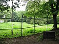
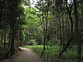
English: Izuminomori is a 42 hectare park in the city of Yamato, Kanagawa, Japan, located approximately 600 metres north of Sagami-Ōtsuka Station. Being a basin containing the source of Hikiji River, it was rice fields until the 1970s. It was opened to public in 1982 upon constructing a flood-control quasi-natural water reservoir. Visit the official website (Japanese).
| Object location | | View all coordinates using: OpenStreetMap |
|---|
park in Yamato, Japan  | |||||
| Upload media | |||||
| Instance of | |||||
|---|---|---|---|---|---|
| Location | Yamato, Kanagawa Prefecture, Japan | ||||
| Located in or next to body of water | |||||
| official website | |||||
 | |||||
Media in category "Izuminomori"
The following 21 files are in this category, out of 21 total.
-
 Hikijigawa -01.jpg 2,592 × 1,944; 1.62 MB
-
 Izuminomori -01.jpg 2,592 × 1,944; 1.86 MB
-
 Izuminomori -02.jpg 2,592 × 1,944; 1.68 MB
-
 Izuminomori -03.jpg 2,592 × 1,944; 1.65 MB
-
 Izuminomori -04.jpg 2,592 × 1,944; 1.55 MB
-
 Izuminomori -05.jpg 2,592 × 1,944; 1.33 MB
-
 Izuminomori Park 01.jpg 1,600 × 1,067; 386 KB
-
 Izuminomori Park 02.jpg 1,600 × 1,067; 383 KB
-
 Izuminomori Park 03.jpg 1,600 × 1,067; 399 KB
-
 Izuminomori Park 04.jpg 1,600 × 1,067; 146 KB
-
 Izuminomori Park 05.jpg 1,600 × 1,067; 375 KB
-
 Kitajima house -01.jpg 2,592 × 1,944; 1.85 MB
-
 Kitajima house -02.jpg 4,245 × 2,659; 1.11 MB
-
 Kitajima house -03.jpg 1,944 × 2,592; 1.28 MB
-
 Kitajima house -04.jpg 2,592 × 1,944; 1.9 MB
-
 Midorinokakehashi -01.jpg 2,592 × 1,944; 1.39 MB
-
 Ogawa house -01.jpg 2,592 × 1,944; 1.56 MB
-
 Ogawa house -02.jpg 3,750 × 2,568; 1.01 MB
-
 泉の森の木橋, The Wood Bridge at Izumi no mori Park - panoramio.jpg 3,456 × 2,304; 972 KB
-
 泉の森公園の水車, Japanese Water wheel - panoramio.jpg 2,199 × 3,228; 733 KB
-
 泉の森公園の池, The pond of Izuminomori Park - panoramio.jpg 3,456 × 2,304; 839 KB


