Category:Jakobskapelle (Tafers)
Jump to navigation
Jump to search
| Object location | | View all coordinates using: OpenStreetMap |
|---|
chapel building and part of a building ensemble in Tafers in the canton of Fribourg    | |||||
| Upload media | |||||
| Instance of | |||||
|---|---|---|---|---|---|
| Part of | |||||
| Location | Tafers, Sense District, Canton of Fribourg, Switzerland | ||||
| Street address |
| ||||
| Heritage designation |
| ||||
 | |||||
Subcategories
This category has only the following subcategory.
A
Media in category "Jakobskapelle (Tafers)"
The following 15 files are in this category, out of 15 total.
-
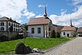
 Jakobskapelle-Tafers.JPG 2,592 × 3,888; 4.07 MB
-
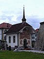
 Tafers Jakobskapelle 733.jpg 7,544 × 5,029; 29.12 MB
-
 Tafers Jakobskapelle 740.jpg 5,152 × 7,728; 22.12 MB
-
 Tafers Jakobskapelle 741.jpg 7,728 × 5,152; 22.73 MB
-
 Tafers Jakobskapelle 742.jpg 7,728 × 5,152; 25.02 MB
-
 Tafers Jakobskapelle 774.jpg 5,152 × 7,728; 33.24 MB
-
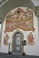
 Tafers Jakobskapelle Jakobus 737.jpg 5,134 × 7,700; 24.34 MB
-
 Tafers Michaelskapelle 770.jpg 5,089 × 7,633; 26.49 MB
-
 Tafers Saint-Martin 2011-07-24 18 28 31 PICT3538.JPG 1,704 × 2,272; 2.04 MB
-
 Tafers Saint-Martin 2011-07-24 18 29 14 PICT3540.JPG 1,704 × 2,272; 1.94 MB
-
 Tafers Saint-Martin 2011-07-24 18 29 33 PICT3541.JPG 1,704 × 2,272; 2.33 MB
-
 Tafers Saint-Martin 2011-07-24 18 29 44 PICT3542.JPG 1,704 × 2,272; 2.68 MB
-
 Tafers Saint-Martin 2011-07-24 18 30 04 PICT3543.JPG 2,272 × 1,704; 2.39 MB
-
 Tafers Saint-Martin 2011-07-24 18 30 19 PICT3544.JPG 2,272 × 1,704; 2.3 MB
-
 Tafers Saint-Martin 2011-07-24 18 30 41 PICT3545.JPG 1,704 × 2,272; 2.08 MB


