Category:Joods monument (Sneek)
Jump to navigation
Jump to search
| Object location | | View all coordinates using: OpenStreetMap |
|---|
Sneek  | |||||
| Upload media | |||||
| Instance of | |||||
|---|---|---|---|---|---|
| Genre | |||||
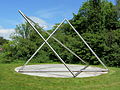
| Location | Sneek, Súdwest-Fryslân, Friesland, Netherlands | ||||
| Street address |
| ||||
| Creator | |||||
| Inception |
| ||||
| Date of official opening |
| ||||
 | |||||
Media in category "Joods monument (Sneek)"
The following 3 files are in this category, out of 3 total.
-
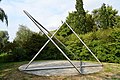 20180828 Joods monument door Dirk Hakze Sneek.jpg 5,184 × 3,456; 4.55 MB
-
 Joods monument sneek.JPG 3,648 × 2,736; 2.14 MB
-
 Joods Monument,Sneek.JPG 2,534 × 1,900; 2.49 MB

