Category:Joodse Begraafplaats (Utrecht)
Jump to navigation
Jump to search
| Object location | | View all coordinates using: OpenStreetMap |
|---|
 | |||||
| Upload media | |||||
| Instance of | |||||
|---|---|---|---|---|---|
| Part of | |||||
| Location | Utrecht, Netherlands | ||||
| Located on street | |||||
| Owned by |
| ||||
| Heritage designation |
| ||||
 | |||||
Deutsch: Die Jüdischer Friedhof ist ein Friedhof auf dem Zandpad 2 in der niederländischen Stadt Utrecht.
Nederlands: De Joodse begraafplaats is een begraafplaats aan het Zandpad 2 in de Nederlandse stad Utrecht.
|
This is a category about rijksmonumentcomplex number 514446
|
Poortgebouw:
|
This is a category about rijksmonument number 514447
|
Baarhuisje:
|
This is a category about rijksmonument number 514448
|
Aanleg met staande grafstenen:
|
This is a category about rijksmonument number 514449
|
| Address |
|
Media in category "Joodse Begraafplaats (Utrecht)"
The following 10 files are in this category, out of 10 total.
-
 Graf Abraham Groen, Utrecht.JPG 2,712 × 3,616; 3.78 MB
-
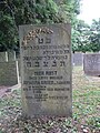 Graf Johanna Groen-Sanders, Utrecht.jpg 750 × 1,000; 136 KB
-
 Jewish cemetery utrecht.jpg 1,944 × 2,592; 1.16 MB
-
 Jewish cemetery2 utrecht.jpg 2,592 × 1,944; 1.15 MB
-
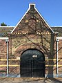 Poortgebouw Utrecht, Zandweg, Joods begraafplaats..jpg 2,448 × 3,264; 2.84 MB
-
 Rijksmonument514447.JPG 2,560 × 1,920; 1,014 KB
-
 Rijksmonument514448.JPG 2,560 × 1,920; 1.06 MB
-
 Rijksmonument514449.JPG 1,920 × 2,560; 1.1 MB
-
-
 Toegangspoort van de Joodse begraafplaats aan de Vecht.jpg 4,770 × 3,177; 4.52 MB


