Category:Judenviertel, Gochsheim
Jump to navigation
Jump to search
| Object location | | View all coordinates using: OpenStreetMap |
|---|
Deutsch: {| style="border-spacing: 0; min-width:300px; max-width:600px; text-align:left; color:#000; background:#ddd; border:1px solid #bbb; margin:0px; direction:ltr;" class="layouttemplate"
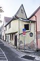
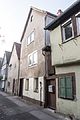
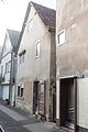
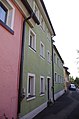
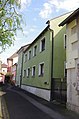
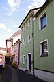
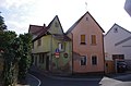
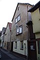
Ehemaliges jüdisches Wohnviertel, Kleinhäuser mit Satteldach und Fachwerk, Judenhof Nr. 2, 4, 6 und 16, 18, 20, 22. 18./19. Jahrhundert, ehemaliges Gemeindehaus und Synagoge (Nr. 16–18), 1754 und 1920, teilweise verändert; Haderngasse 3, Gochsheim, Landkreis Schweinfurt,Unterfranken, Deutschland
| style="width:22px; height:22px;" | ![]()
This is the category of the Bavarian Baudenkmal (cultural heritage monument) with the ID
D-6-78-135-31 (Wikidata)
|}
This is the category of the Bavarian Baudenkmal (cultural heritage monument) with the ID D-6-78-135-32 (Wikidata)
|
cultural heritage monument D-6-78-135-32 (0) in Gochsheim, Bavaria  | |||||
| Upload media | |||||
| Instance of | |||||
|---|---|---|---|---|---|
| Location | Gochsheim, Schweinfurt, Lower Franconia, Bavaria, Germany | ||||
| Street address |
| ||||
| Heritage designation | |||||
 | |||||
Media in category "Judenviertel, Gochsheim"
The following 19 files are in this category, out of 19 total.
-
 D-6-78-135-32 Judenhof (2).jpg 3,784 × 5,512; 8.44 MB
-
 D-6-78-135-32 Judenhof.jpg 4,644 × 3,851; 6.15 MB
-
 Gochsheim, Judenhof 2-20161031-001.jpg 4,003 × 5,996; 12.63 MB
-
 Gochsheim, Judenhof 2-20161031-002.jpg 4,003 × 5,996; 11.12 MB
-
 Gochsheim, Judenhof 4-20161031-001.jpg 4,003 × 5,996; 11.24 MB
-
 Gochsheim, Judenhof 6-20161031-001.jpg 4,003 × 5,996; 12.08 MB
-
 Gochsheim-Judenhof 2 001.JPG 3,264 × 4,928; 4.9 MB
-
 Gochsheim-Judenhof 2 002.JPG 3,264 × 4,928; 4.64 MB
-
 Gochsheim-Judenhof 2, 4, 6 001.JPG 3,264 × 4,928; 6.41 MB
-
 Judenhof 16, 18 Gochsheim.jpg 3,264 × 4,928; 7.21 MB
-
 Judenhof 16-22 Gochsheim.jpg 3,264 × 4,928; 7.23 MB
-
 Judenhof 18-22.jpg 3,264 × 4,928; 7.02 MB
-
 Judenhof 2 Gochsheim.jpg 4,928 × 3,264; 6.52 MB
-
 Judenhof 2 Haderngasse 3 Gochsheim.jpg 4,928 × 3,264; 6.85 MB
-
 Judenhof 2, 4, 6 Gochsheim.jpg 3,264 × 4,928; 6.49 MB
-
 Judenhof 20, 22 Gochsheim.jpg 3,264 × 4,928; 6.91 MB
-
 Judenhof 4 und 6 Gochsheim.jpg 3,264 × 4,928; 6.42 MB
-
 Judenhof 6 Gochsheim 1.jpg 3,264 × 4,928; 7.18 MB
-
 Judenhof 6 Gochsheim 2.jpg 3,264 × 4,928; 6.37 MB
.jpg)


