Category:July 2022 in the Scottish Borders
Jump to navigation
Jump to search
Council areas (municipalities) of Scotland: Argyll and Bute · Edinburgh · Glasgow · Highland · Midlothian · Orkney Islands · Perth and Kinross · Scottish Borders · South Ayrshire · Stirling ·
Deutsch: Bilder, die im Juli 2022 in the Scottish Borders aufgenommen worden sind. Bitte beachten Sie, dass dies weder das Datum des Uploads noch das Datum des Scannens eines Fotos ist.
English: Images/pictures taken in the Scottish Borders during July 2022. Note this is not the date of the upload, nor the date a photo was scanned.
Español: Fotografías o imágenes tomadas en the Scottish Borders durante julio 2022. No es la fecha de subida ni escaneo, sino la fecha en que las fotografías o imágenes se crearon.
Esperanto: Bildoj faritaj en the Scottish Borders en julio 2022. Tio ne estas la dato, kiam la bildoj estis alŝutitaj aŭ skanitaj.
Français : Photographies ou images prises en the Scottish Borders durant juillet 2022. Ce n'est pas la date du téléchargement ou du scan.
Galego: Fotografías ou imaxes tomadas en the Scottish Borders durante xullo 2022. Non é a data de subida nin escaneamento, senón a data na que se crearon as fotografías ou imaxes.
Italiano: Fotografie o immagini scattate a the Scottish Borders nel luglio 2022. Nota bene: la data non si riferisce né a quella di upload né a quella in cui la foto è stata digitalizzata.
Norsk bokmål: Bilder tatt i the Scottish Borders i løpet av juli 2022. Merk at dette ikke er datoen for opplasting, eller når et bilde har blitt skannet.
Norsk nynorsk: Bilete teke i the Scottish Borders i løpet av juli 2022. Merk at dette ikkje er datoen for opplasting, eller når eit bilete har vorte skanna.
Русский: Изображения, сделанные в the Scottish Borders в течение июль 2022 (не дата загрузки изображения).
Українська: Зображення, зроблені в the Scottish Borders протягом липень 2022. Зауважте, що це не дата завантаження чи дата сканування фотографії.
| July 2021 | ← | July 2022 | → | July 2023 | |||||||
| Jan | Feb | Mar | Apr | May | Jun | Jul | Aug | Sep | Oct | Nov | Dec |
| 1 | 0 | 2 | 0 | 4 | 2 | 42 | 0 | 0 | 0 | 0 | 1 |
|---|---|---|---|---|---|---|---|---|---|---|---|
Media in category "July 2022 in the Scottish Borders"
The following 42 files are in this category, out of 42 total.
-
 Dryburgh Abbey Area Ruins 1.jpg 4,000 × 6,000; 13.73 MB
-
 Dryburgh Abbey Area Ruins 2.jpg 3,920 × 5,776; 13.73 MB
-
 Dryburgh Abbey Area Ruins 3.jpg 3,832 × 5,758; 15.04 MB
-
 Dryburgh Abbey Area Ruins 4.jpg 4,000 × 6,000; 16.91 MB
-
 Dryburgh Abbey Area Ruins 5.jpg 3,792 × 5,552; 15.87 MB
-
 Dryburgh Abbey Area Ruins 6.jpg 4,000 × 6,000; 17.12 MB
-
 Dryburgh Abbey Area Ruins 7.jpg 4,000 × 6,000; 15.35 MB
-
 Dryburgh Abbey Area Ruins 8.jpg 5,688 × 3,772; 15.06 MB
-
 Dryburgh Abbey Entrance alley seen from the east.jpg 4,000 × 6,000; 15.57 MB
-
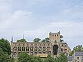 Jedburgh Abbey main building seen from the parking lot.jpg 5,364 × 4,000; 11.11 MB
-
 Jedburgh Trinity Parish Church seen from the northwest.jpg 4,000 × 6,000; 12.5 MB
-
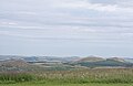 Jedburgh View from the Border viewpoint to the northeast.jpg 6,000 × 3,904; 11.12 MB
-
 Melrose Abbey Building in the eastern wall seen from Commendators House.jpg 4,000 × 4,960; 12.83 MB
-
 Melrose Abbey Commendators House seen from the southeast.jpg 6,000 × 4,000; 15.95 MB
-
 Melrose Abbey Eastern wall detail.jpg 6,000 × 4,000; 14.87 MB
-
 Melrose Abbey panorama and Eildon Hill North seen from Commendators House.jpg 5,808 × 3,736; 10.8 MB
-
 Melrose Abbey panorama seen from the south.jpg 5,832 × 3,880; 14.21 MB
-
 Melrose Abbey Southern wall detail 1.jpg 3,888 × 5,776; 16.35 MB
-
 Melrose Abbey Southern wall detail 2.jpg 4,000 × 6,000; 14.03 MB
-
 Melrose Abbey Southern wall detail 3.jpg 4,000 × 6,000; 15.66 MB
-
 Melrose Abbey Southern wall of the apse detail 1.jpg 4,000 × 5,872; 14.37 MB
-
 Melrose Abbey Southern wall of the apse detail 2.jpg 4,000 × 5,888; 14.2 MB
-
 Melrose Abbey Street seen from Market Square.jpg 3,776 × 5,536; 11.13 MB
-
 Melrose Abbey Western wall detail.jpg 4,000 × 5,872; 12.23 MB
-
 Melrose Eildon Mid Hill seen from St. Mary's Road.jpg 6,000 × 4,000; 10.88 MB
-
 Melrose former railway station gallery.jpg 3,904 × 5,872; 14.09 MB
-
 Melrose former railway station seen from the northeast.jpg 3,236 × 4,688; 7.41 MB
-
 Melrose former railway station seen from the southeast.jpg 6,000 × 4,000; 14.08 MB
-
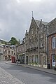
 Melrose High Street eastern side.jpg 3,840 × 5,616; 9.93 MB
-
 Melrose Market Square Burt's Hotel.jpg 3,872 × 5,616; 11.43 MB
-
 Melrose Market Square north side seen from Dingleton Road.jpg 4,000 × 5,632; 11.77 MB
-
 Melrose Market Square south side.jpg 4,000 × 6,000; 11.64 MB
-
 Melrose River Tweed seen downstream from above the church.jpg 6,000 × 4,000; 13.56 MB
-
 Melrose River Tweed seen upstream from above the church.jpg 6,000 × 4,000; 12.12 MB
-
 Melrose Roofs seen from the former railway station.jpg 5,736 × 3,712; 10.53 MB
-
 Melrose Scabbet Hill seen from Melrose Abbey.jpg 5,820 × 3,768; 13.6 MB
-
 Redpath Scott's View 1.jpg 6,000 × 4,000; 13.75 MB
-
 Redpath Scott's View 2.jpg 6,000 × 4,000; 11.99 MB
-
 Redpath Scott's View 3.jpg 6,000 × 4,000; 12.93 MB
-
 Stow of Wedale Sell Moor Hill seen from Earlston Road upwards.jpg 5,844 × 3,928; 13.77 MB
-
 Stow of Wedale Wind turbines seen from Earlston Road downwards 1.jpg 6,000 × 4,000; 11.83 MB
-
 Stow of Wedale Wind turbines seen from Earlston Road downwards 2.jpg 6,000 × 4,000; 11.25 MB


