Category:Königlich-Sächsische Triangulirung Station 31 Baselitz
Jump to navigation
Jump to search
| (Wikidata) |
| Object location | | View all coordinates using: OpenStreetMap |
|---|
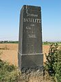
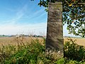
Triangulation Column, 1nd Order Station, the Royal Saxon Triangulation in Saxony 1862-1890  | |||||
| Upload media | |||||
| Instance of |
| ||||
|---|---|---|---|---|---|
| Part of | |||||
| Location | Priestewitz, Meissen District, Saxony, Germany | ||||
| Street address |
| ||||
| Heritage designation | |||||
| Inception |
| ||||
 | |||||
Media in category "Königlich-Sächsische Triangulirung Station 31 Baselitz"
The following 6 files are in this category, out of 6 total.
-
 Baselitz.jpg 1,200 × 1,600; 454 KB
-
 Station 31 Baselitz-01.jpg 5,333 × 4,000; 2.56 MB
-
 Station 31 Baselitz-02.jpg 6,000 × 4,000; 2.39 MB
-
 Station 31 Baselitz-03.jpg 6,000 × 4,000; 2.63 MB
-
 Station 31 Baselitz-04.jpg 5,151 × 3,863; 2.88 MB
-
 Station 31 Baselitz.jpg 3,836 × 5,115; 2.69 MB


