Category:Kaai 75, Veere
Jump to navigation
Jump to search
| Object location | | View all coordinates using: OpenStreetMap |
|---|
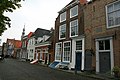
house in Veere, Netherlands  | |||||
| Upload media | |||||
| Instance of | |||||
|---|---|---|---|---|---|
| Location | Veere, Zeeland, Netherlands | ||||
| Street address |
| ||||
| Located on street | |||||
| Heritage designation |
| ||||
 | |||||
Nederlands: De Mereminno
|
This is a category about rijksmonument number 36909
|
| Address |
|
Media in category "Kaai 75, Veere"
The following 6 files are in this category, out of 6 total.
-
 Overzicht - Veere - 20239574 - RCE.jpg 1,200 × 956; 296 KB
-
 Overzicht - Veere - 20239584 - RCE.jpg 1,200 × 949; 215 KB
-
 Overzicht - Veere - 20239585 - RCE.jpg 1,200 × 956; 249 KB
-
 Tussen Wijngaardstraat en Kapellestraat - Veere - 20239516 - RCE.jpg 1,200 × 954; 277 KB
-
 Veere - Kaai 75 - Pand genaamd De Mereminno..jpg 3,888 × 2,592; 5.9 MB
-
 Zeeland (31720768190).jpg 5,184 × 3,456; 6.17 MB


.jpg)