Category:Kandersteg
Zur Navigation springen
Zur Suche springen
Gemeinde im Kanton Bern in der Schweiz     | |||||
| Medium hochladen | |||||
| Isch e | |||||
|---|---|---|---|---|---|
| Ort | |||||
| Amtssproch | |||||
| Gebirgszug | |||||
| Yywohnerzahl |
| ||||
| Flechi |
| ||||
| Hechi iber em Meeresspiegel |
| ||||
| offizielli Homepage | |||||
 | |||||
Unterkategorie
S wäre 24 vu insgsamt 24 Unterkategorie in däre Kategori aazeigt:
A
B
- Balmhorn (81 D)
- Balmhorngletscher (15 D)
C
D
- Doldenhorn (1 S, 63 D)
- Dündenhorn (9 D)
F
- Fründenhorn (18 D)
G
- Gällihore (12 D)
H
- Historical images of Kandersteg (46 D)
K
- Kander at Kandersteg (14 D)
- Kanderfirn (11 D)
O
S
T
Ö
- Öschibach (8 D)
Ü
- Üssere Fisistock (15 D)
Artikel in de Kategori "Kandersteg"
S wäre 2 vu insgsamt 2 Syte in däre Kategori aazeigt:
Medie in dr Kategori „Kandersteg“
S wäre 122 vu insgsamt 122 Dateie in däre Kategori aazeigt:
-
 Above Kandersteg, June 2021 11 50 51 166000.jpeg 4.032 × 3.024; 3,29 MB
-
 Above Kandersteg, June 2021 11 51 08 936000.jpeg 4.032 × 3.024; 5,32 MB
-
 Above Kandersteg, June 2021.jpeg 4.032 × 3.024; 5,26 MB
-
 Alfa-Soleil http-www.alfasoleil.ch - panoramio.jpg 2.007 × 1.253; 523 KB
-
 Allmenalp - panoramio.jpg 3.872 × 2.592; 3,18 MB
-
 Almenalp - panoramio.jpg 3.872 × 2.592; 3,6 MB
-
 Almenalp Klettersteig - panoramio - Jan Uyttebroeck (1).jpg 3.742 × 2.339; 3,58 MB
-
 Almenalp Klettersteig - panoramio - Jan Uyttebroeck.jpg 3.548 × 2.425; 4,21 MB
-
 Almenalp Klettersteig - panoramio.jpg 3.633 × 2.309; 3,7 MB
-
 Arvenseeli im Berner Oberland.jpg 6.016 × 4.000; 12,79 MB
-
 Arvenseeli in der Berner Gemeinde Kandersteg.jpg 6.016 × 4.000; 14,13 MB
-
 Arvenseeli in Kandersteg im Berner Oberland.jpg 6.016 × 4.000; 14,32 MB
-
 Arvenseeli in Kandersteg im Hochplateau Sunnebüel.jpg 6.016 × 4.000; 13,72 MB
-
 Arvenseeli in Kandersteg.jpg 6.016 × 4.000; 13,88 MB
-
 Arvenseeli.jpg 6.016 × 4.000; 13,66 MB
-
 Balmhorn from Allmenalp.jpg 1.600 × 1.200; 307 KB
-
 Beauty of swiss mountains.jpg 2.030 × 1.522; 368 KB
-
 Belle Epoque Hotel Victoria.jpg 4.080 × 3.072; 2,45 MB
-
 Blue See (5307261823).png 2.592 × 1.944; 9 MB
-
 Blümlisalp 2.jpg 3.072 × 4.080; 1,51 MB
-
 Bunderchrinde Pass.jpg 4.080 × 3.072; 4,1 MB
-
 Bunderspitz 3.jpg 4.080 × 3.072; 4,36 MB
-
 CH-NB Photoglob-Wehrli EAD-WEHR-24725-B.tif 7.413 × 5.597, 2 Syte; 79,2 MB
-
 CH-NB Photoglob-Wehrli EAD-WEHR-24726-B.tif 7.413 × 5.597, 2 Syte; 79,2 MB
-
 Chapel of Kandersteg in autumn - panoramio.jpg 2.808 × 1.872; 1,63 MB
-
 Curling at Kandersteg.jpg 1.968 × 1.944; 1,43 MB
-
 Denkmal Lötschbergunglück1.JPG 3.648 × 2.736; 2,09 MB
-
 Denkmal Lötschbergunglück2.JPG 3.648 × 2.736; 2,13 MB
-
 Doldernhornhutte - panoramio.jpg 3.872 × 2.592; 4,09 MB
-
 Early skis at the Belle Epoque Festival in Kandersteg.jpg 3.840 × 5.760; 6,95 MB
-
 Eggeschwand, Kandersteg BE 20220712-jag9889.jpg 4.608 × 3.456; 11,69 MB
-
 Eispickelschmiede Kandersteg 1906.jpg 1.600 × 1.200; 626 KB
-
 Forest on a rocky hill (Unsplash).jpg 3.500 × 2.336; 5,41 MB
-
 Fruendenschnur.jpg 4.000 × 2.664; 2,67 MB
-
 Gastnertal - panoramio - Jan Uyttebroeck (1).jpg 3.496 × 2.340; 3,66 MB
-
 Gastnertal - panoramio - Jan Uyttebroeck.jpg 3.872 × 2.592; 1,79 MB
-
 Gastnertal - panoramio.jpg 3.872 × 2.592; 2,13 MB
-
 Girl ice skating in Kandersteg in front of Blüemlisalp.jpg 3.199 × 3.840; 1,87 MB
-
 Glaciers next to Oeschinensee.jpeg 4.032 × 3.024; 2,59 MB
-
 Gällihorn from Gratsattel.jpg 5.751 × 6.375; 8,61 MB
-
 Heimritz-1632m - panoramio.jpg 3.000 × 2.008; 1,6 MB
-
 ISS006-E-44352 - View of Switzerland.jpg 3.032 × 2.064; 1,69 MB
-

-

-
 Kandersteg Allmenalp tou Oeschienensee - panoramio.jpg 3.000 × 2.008; 1,43 MB
-
 Kandersteg Ansicht.jpg 2.448 × 1.836; 449 KB
-
 Kandersteg area in summer 2011 (1).JPG 4.752 × 3.168; 6,45 MB
-
 Kandersteg area in summer 2011 (2).JPG 4.752 × 3.168; 8,14 MB
-
 Kandersteg area in summer 2011 (3).JPG 4.752 × 3.168; 7,83 MB
-
 Kandersteg area in summer 2011 (4).JPG 4.752 × 3.168; 6,52 MB
-
 Kandersteg area in summer 2011 (5).JPG 4.752 × 3.168; 6,72 MB
-
 Kandersteg area in summer 2011 (6).JPG 4.752 × 3.168; 8,6 MB
-
 Kandersteg area in summer 2011 (7).JPG 4.752 × 3.168; 6,73 MB
-
 Kandersteg area in summer 2011 (8).JPG 4.752 × 3.168; 6,2 MB
-
 Kandersteg Aug2012.jpg 5.184 × 3.456; 7,73 MB
-
 Kandersteg before sunset.jpg 5.120 × 2.368; 4,69 MB
-
 Kandersteg Church.jpg 5.184 × 3.456; 9,83 MB
-
 Kandersteg D8A 8687.jpg 4.912 × 7.360; 13,25 MB
-
 Kandersteg D8A 8893.jpg 4.912 × 7.360; 22,31 MB
-
 Kandersteg D8A 8898-3.jpg 4.912 × 7.360; 18,32 MB
-
 Kandersteg D8A 8976.jpg 4.912 × 7.360; 22,41 MB
-
 Kandersteg Doldenhorn.jpg 594 × 392; 62 KB
-
 Kandersteg from south west.jpg 3.648 × 2.736; 3,42 MB
-
 Kandersteg in Winter.jpg 4.290 × 2.472; 2,9 MB
-
 Kandersteg lötschberg tunnel - panoramio.jpg 3.872 × 2.592; 4,83 MB
-
 Kandersteg Seilbahn Sunnbüel.jpg 5.184 × 3.888; 6,46 MB
-
 Kandersteg talwärts.jpg 5.184 × 3.888; 5,57 MB
-
 Kandersteg Valley.jpg 5.184 × 3.038; 10,97 MB
-
 Kandersteg von Allmenbahn.jpg 4.048 × 3.219; 3,32 MB
-
 Kandersteg Wikivoyage Banner.JPG 4.752 × 679; 1,69 MB
-
 Kandersteg-Hauptstrasse.jpg 1.200 × 800; 1.013 KB
-
 Kandersteg.jpeg 400 × 590; 92 KB
-
 KanderstegChairlift2.JPG 1.728 × 2.304; 2,61 MB
-
 Kanderthal 1.jpg 3.024 × 4.032; 11,91 MB
-
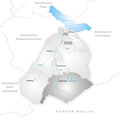
 Karte Gemeinde Kandersteg 2007.png 1.181 × 1.181; 281 KB
-
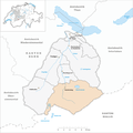
 Karte Gemeinde Kandersteg.png 944 × 945; 178 KB
-
 Karte Oeschinensee.png 1.181 × 747; 259 KB
-
 Klettersteig Allmenalp Kandersteg.jpg 1.704 × 2.272; 1,51 MB
-
 Milky Way Galaxy and Kandersteg viewed from the Blümlisalphütte at night.jpg 8.228 × 4.947; 33,94 MB
-
 Mountain cliff.jpg 5.456 × 3.632; 6,41 MB
-
 Mt.Bire from Kandersteg - panoramio.jpg 4.752 × 3.168; 2,19 MB
-
 Oeschibach in Kandersteg in Winter.jpg 5.760 × 3.840; 9,66 MB
-
 Open air ice skating in Kandersteg.jpg 5.760 × 3.840; 7,02 MB
-
 Pano Altels (44931522).jpeg 2.048 × 708; 310 KB
-
 Panoramic view from the Hockenhorn - panoramio (2).jpg 18.756 × 2.132; 9,4 MB
-
 Panoramic view from the Hockenhorn - panoramio (4).jpg 16.556 × 2.415; 9,01 MB
-
 Panoramic view from the Hockenhorn - panoramio (5).jpg 14.203 × 2.816; 8,97 MB
-
 Panoramic view from the Hockenhorn - panoramio (7).jpg 16.471 × 2.428; 8,19 MB
-
 Panoramic view from the Hockenhorn - panoramio.jpg 14.240 × 2.808; 8,13 MB
-
 Panoramic view from the Hockenhorngrat - panoramio.jpg 12.468 × 3.208; 6,99 MB
-
 Plant on Bernese Alps.jpg 2.652 × 2.652; 1,23 MB
-
 Platy stones.jpg 2.890 × 4.761; 4,09 MB
-
 Rain-soaked colors.jpg 1.616 × 1.080; 485 KB
-
 Red green plant.jpg 855 × 877; 284 KB
-
 Reformierte Kirche, Kandersteg, in 2022, Q55412370.jpg 3.072 × 4.080; 3,23 MB
-
 Schwarenbach2870.JPG 2.048 × 1.536; 1,83 MB
-
 Snow on the Altels (Unsplash).jpg 3.735 × 2.500; 6,95 MB
-
 SSchlageter Kandersteg SSC4706.jpg 3.456 × 4.608; 14,09 MB
-
 SSchlageter Kandersteg SSC4709.jpg 3.456 × 4.608; 12,4 MB
-
 Stones and grass.jpg 5.392 × 2.840; 4,09 MB
-
 Stundenstein Kandersteg.tif 2.400 × 3.389; 31,05 MB
-
 Swisstopo 1.jpg 800 × 800; 500 KB
-
 Swisstopo 2.jpg 800 × 800; 623 KB
-
 Swisstopo 3.jpg 800 × 800; 701 KB
-
 Swisstopo 4.jpg 800 × 800; 664 KB
-
 Swisstopo 5.jpg 800 × 800; 660 KB
-
 Swisstopo 6.jpg 800 × 800; 586 KB
-
 Swisstopo 7.jpg 800 × 800; 467 KB
-
 Swisstopo 8.jpg 800 × 800; 445 KB
-
 Switzerland - mountain 5.jpg 4.112 × 2.824; 3,08 MB
-
 Switzerland - mountain panorama 4.jpg 17.190 × 3.055; 12,74 MB
-
 Trail mark on stone 3.jpg 5.456 × 3.632; 6,54 MB
-
 Trail on mountain 7.jpg 5.456 × 3.632; 8,28 MB
-
 Trail signs 4.jpg 4.760 × 3.632; 5,48 MB
-
 Trail signs 5.jpg 1.776 × 1.048; 704 KB
-
 Valaisan Sheep.jpg 3.024 × 4.032; 4,47 MB
-
 View from Kandersteg to Blüemlisalp in snow.jpg 5.760 × 3.840; 8,84 MB
-
 Water in glacier.jpg 5.456 × 3.632; 5,76 MB
-
 WP Hockenhorn 180908 Breithorn Tellispitze.jpg 3.203 × 2.198; 4,38 MB
-
 WP Hockenhorn Petersgrat 180908.jpg 6.720 × 4.480; 15,25 MB
-
 Yawning husky on snow (Unsplash).jpg 6.000 × 4.000; 12,22 MB
-
 Zij- en voorgevel nr. Z 4021 - Unknown - 20513419 - RCE.jpg 1.200 × 900; 206 KB


.jpg)


.png)


.jpg)

.jpg)


.JPG)
.JPG)
.JPG)
.JPG)
.JPG)
.JPG)
.JPG)
.JPG)


.jpg)


.jpg)

.jpeg)
.jpg)
.jpg)
.jpg)
.jpg)