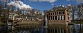
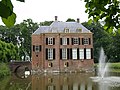
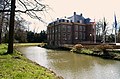
Category:Kasteel Neerijnen
Jump to navigation
Jump to search
| Object location | | View all coordinates using: OpenStreetMap |
|---|
| Upload media | |||||
| Instance of | |||||
|---|---|---|---|---|---|
| Location | Neerijnen, Gelderland, Netherlands | ||||
| Has part(s) | |||||
| Heritage designation |
| ||||
 | |||||
Nederlands: Kasteel Neerijnen
|
This is a category about rijksmonumentcomplex number 520222
|
Hoofdgebouw:
|
This is a category about rijksmonument number 520223
|
Historische aanleg:
|
This is a category about rijksmonument number 520245
|
Voorburcht met keermuur en toegangsbrug:
|
This is a category about rijksmonument number 520246
|
Koetshuis:
|
This is a category about rijksmonument number 520247
|
Ophaalbrug:
|
This is a category about rijksmonument number 520248
|
Moestuinensemble:
|
This is a category about rijksmonument number 520249
|
| Address |
|
Media in category "Kasteel Neerijnen"
The following 35 files are in this category, out of 35 total.
-
 520223 Kasteel Neerijnen (2).jpg 4,608 × 3,456; 13.48 MB
-
 520223 Kasteel Neerijnen (3).jpg 3,640 × 1,500; 5.24 MB
-
 520223 Kasteel Neerijnen (4).jpg 3,000 × 1,585; 4.8 MB
-
 520223 Kasteel Neerijnen.jpg 3,000 × 2,250; 6.98 MB
-
 Achtergevel - Neerijnen - 20163301 - RCE.jpg 1,192 × 1,200; 470 KB
-
 Bijgebouw - Neerijnen - 20163302 - RCE.jpg 1,192 × 1,200; 457 KB
-
 Bijgebouw - Neerijnen - 20163303 - RCE.jpg 1,188 × 1,200; 360 KB
-
 Bronzen deurgreep - Neerijnen - 20163294 - RCE.jpg 1,200 × 895; 300 KB
-
 Gemeentehuis (town hall) Neerijnen - panoramio.jpg 3,264 × 2,448; 1.86 MB
-
 Gemeentehuis (townhall) Neerijnen - panoramio.jpg 3,264 × 2,448; 1.56 MB
-
 Ingang - Neerijnen - 20163293 - RCE.jpg 898 × 1,200; 212 KB
-
 Kasteel Neerijnen (1).jpg 3,669 × 3,115; 4.29 MB
-
 Kasteel Neerijnen (2).jpg 4,532 × 3,448; 6.22 MB
-
 Kasteel Neerijnen Koetshuis.jpg 4,573 × 3,379; 7.71 MB
-
 Kasteel Neerijnen Moestuin (1).jpg 3,425 × 4,580; 7.52 MB
-
 Kasteel Neerijnen Moestuin (2).jpg 4,549 × 3,451; 9.32 MB
-
 Kasteel Neerijnen Moestuin (3).jpg 4,429 × 3,061; 7.57 MB
-
 Kasteel Neerijnen Moestuin Kassen.jpg 3,773 × 3,350; 7.67 MB
-
 Kasteel Neerijnen Moestuin Tuinmuur en Kassen.jpg 4,268 × 2,600; 5.9 MB
-
 Kasteel Neerijnen Ophaalbrug.jpg 4,577 × 3,383; 7.18 MB
-
 Kasteel Neerijnen.JPG 1,600 × 1,200; 432 KB
-
 Neerijnen (18).JPG 2,996 × 1,982; 1.56 MB
-
 Neerijnen (23).JPG 3,008 × 2,000; 6.43 MB
-
 Neerijnen (26).JPG 3,008 × 2,000; 7.02 MB
-
 Neerijnen (7).JPG 2,996 × 1,982; 1.48 MB
-
 Neerijnen.jpg 500 × 325; 50 KB
-
 Overzicht - Neerijnen - 20163304 - RCE.jpg 894 × 1,200; 253 KB
-
 Overzicht kasteel - Neerijnen - 20163295 - RCE.jpg 1,197 × 1,200; 377 KB
-
 Overzicht met ophaalbrug - Neerijnen - 20163296 - RCE.jpg 1,174 × 1,200; 356 KB
-
 Voorgevel, ingang met ingangsomlijsting - Neerijnen - 20163305 - RCE.jpg 894 × 1,200; 186 KB
-
 Zij- en achtergevel - Neerijnen - 20163298 - RCE.jpg 1,183 × 1,200; 428 KB
-
 Zij- en achtergevel - Neerijnen - 20163300 - RCE.jpg 1,192 × 1,200; 422 KB
-
 Zij- en kopgevel FRUITSCHUUR - Neerijnen - 20499043 - RCE.jpg 1,200 × 900; 235 KB
-
 Zijgevel - Neerijnen - 20163297 - RCE.jpg 1,192 × 1,200; 385 KB
-
 Zijgevel - Neerijnen - 20163299 - RCE.jpg 1,195 × 1,200; 454 KB
.jpg)
.jpg)


_Neerijnen_-_panoramio.jpg)
_Neerijnen_-_panoramio.jpg)

.jpg)
.jpg)

.jpg)
.jpg)
.jpg)


.JPG)
.JPG)
.JPG)
.JPG)


.jpg)