Category:Kasteel Oude Rande
Jump to navigation
Jump to search
| Object location | | View all coordinates using: OpenStreetMap |
|---|
| Camera location | | View all coordinates using: OpenStreetMap |
|---|
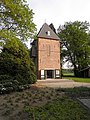
building in Deventer, Netherlands  | |||||
| Upload media | |||||
| Instance of | |||||
|---|---|---|---|---|---|
| Location | Diepenveen, Overijssel, Netherlands | ||||
| Street address |
| ||||
| Heritage designation |
| ||||
 | |||||
|
This is a category about rijksmonument number 12889
|
| Address |
|
Media in category "Kasteel Oude Rande"
The following 11 files are in this category, out of 11 total.
-
 Detail toren huis - Diepenveen - 20057188 - RCE.jpg 805 × 1,200; 257 KB
-
 Havezate Rande op het minuutplan Diepenveen, Overijssel, sectie A, blad 05.jpg 2,184 × 999; 374 KB
-
 Oud Rande in Diepenveen -01.jpg 3,216 × 4,288; 2.91 MB
-
 Oud Rande in Diepenveen -02.jpg 3,216 × 4,288; 3.01 MB
-
 Tijdens sloop - Diepenveen - 20057183 - RCE.jpg 1,200 × 1,194; 316 KB
-
 Tijdens sloop - Diepenveen - 20057184 - RCE.jpg 1,191 × 1,200; 299 KB
-
 Toren - Diepenveen - 20057185 - RCE.jpg 799 × 1,200; 255 KB
-
 Toren - Diepenveen - 20057186 - RCE.jpg 800 × 1,200; 248 KB
-
 Toren - Diepenveen - 20057187 - RCE.jpg 805 × 1,200; 228 KB
-
 Toren naar het noorden - Diepenveen - 20057182 - RCE.jpg 960 × 1,200; 313 KB
-
 Toren naar het zuiden - Diepenveen - 20057181 - RCE.jpg 946 × 1,200; 373 KB


