Category:Katholische Kirche Hennigsdorf
Jump to navigation
Jump to search
| Object location | | View all coordinates using: OpenStreetMap |
|---|
church building in Hennigsdorf, Brandenburg state, Germany  | |||||
| Upload media | |||||
| Instance of | |||||
|---|---|---|---|---|---|
| Location | Hennigsdorf, Oberhavel District, Brandenburg, Germany | ||||
 | |||||
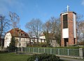
English: Catholic church, Hennigsdorf city, Oberhavel district, Brandenburg state, Germany
Deutsch: Katholische Kirche „Zu den heiligen Schutzengeln“, Stadt Hennigsdorf, Landkreis Oberhavel, Land Brandenburg, Deutschland
Français : Église catholique, ville de Hennigsdorf, arrondissement Haute-Havel, état fédéral de Brandebourg, Allemagne
Media in category "Katholische Kirche Hennigsdorf"
The following 2 files are in this category, out of 2 total.
-
 Hennigsdorf church.jpg 2,896 × 2,120; 996 KB
-
 Hennigsdorf katholische Kirche Ende1920er.jpg 1,000 × 639; 328 KB
