Category:Keizersgracht 630, Amsterdam
Jump to navigation
Jump to search
| Object location | | View all coordinates using: OpenStreetMap |
|---|
.JPG) | |||||
| Upload media | |||||
| Instance of |
| ||||
|---|---|---|---|---|---|
| Location | Amsterdam, North Holland, Netherlands | ||||
| Street address |
| ||||
| Located on street | |||||
| Heritage designation |
| ||||
 | |||||
|
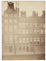
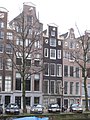
This is a category about rijksmonument number 2682
|
| Address |
|
Media in category "Keizersgracht 630, Amsterdam"
The following 10 files are in this category, out of 10 total.
-
 Albert Greiner Afb ANWQ00340000001.jpg 3,547 × 2,812; 1 MB
-
 Albert Greiner Afb ANWQ00341000001.jpg 3,636 × 2,859; 993 KB
-
 Albert Greiner Afb OSIM00001002907.jpg 2,517 × 1,879; 661 KB
-
 Albert Greiner Afb OSIM00001002934.jpg 1,920 × 2,524; 458 KB
-
 Albert Greiner Afb OSIM00001002948.jpg 2,538 × 1,900; 638 KB
-
 Amsterdam - Keizersgracht 630.JPG 3,056 × 4,592; 4.43 MB
-
 Amsterdam - Keizersgracht 632.JPG 3,056 × 4,592; 5.02 MB
-
 Keizersgracht 628 (midden).JPG 1,944 × 2,592; 757 KB
-
 Keizersgracht 630 (links).JPG 1,944 × 2,592; 729 KB
-
 Keizersgracht 632 (links).JPG 1,944 × 2,592; 728 KB


.JPG)
.JPG)