Category:Kerk van Duurswoude
Jump to navigation
Jump to search
| Object location | | View all coordinates using: OpenStreetMap |
|---|
church building in Opsterland, Netherlands  | |||||
| Upload media | |||||
| Instance of | |||||
|---|---|---|---|---|---|
| Location | Wijnjewoude, Opsterland, Friesland, Netherlands | ||||
| Street address |
| ||||
| Located on street |
| ||||
| Heritage designation |
| ||||
| Inception |
| ||||
| Significant event |
| ||||
| official website | |||||
 | |||||
|
This is a category about rijksmonument number 31839
|
| Address |
|
Subcategories
This category has only the following subcategory.
B
Media in category "Kerk van Duurswoude"
The following 19 files are in this category, out of 19 total.
-
 2023 Duerswâldmer Jehannestsjerke.jpg 2,604 × 2,606; 3.45 MB
-
 2023 Duerswâldmer tsjerke.jpg 3,377 × 2,252; 1.45 MB
-
 Duerswâld tsjerke.JPG 3,264 × 2,233; 3 MB
-
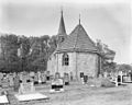
 Exterieur noord-zijde - Duurswoude - 20065509 - RCE.jpg 1,200 × 946; 311 KB
-
 Exterieur oost-zijde - Duurswoude - 20065511 - RCE.jpg 1,200 × 960; 278 KB
-
 Exterieur zuid-zijde - Duurswoude - 20065510 - RCE.jpg 1,200 × 957; 281 KB
-
 Hervormde kerk Wijnjewoude.jpg 1,352 × 640; 162 KB
-
 Interieur naar het oosten - Duurswoude - 20065508 - RCE.jpg 1,200 × 961; 184 KB
-
 Interieur naar het westen - Duurswoude - 20065507 - RCE.jpg 1,200 × 968; 176 KB
-
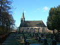 Kerk van Duurswoude.jpg 2,592 × 1,944; 824 KB
-
 Kerkje van Duurswoude in de stijgers.JPG 4,608 × 3,456; 3.75 MB
-
 Kerkje van Wijnjewoude- Duurswoude.jpg 1,600 × 1,067; 295 KB
-
 Noardmuorre.JPG 3,264 × 2,448; 3.73 MB
-
 Noord-zijde - Duurswoude - 20065512 - RCE.jpg 1,200 × 951; 226 KB
-

-
 Tsjerke fan Duerswâld, koer.jpg 4,608 × 3,456; 2.74 MB
-
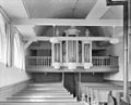
 Tsjerke fan Duerswâld, oargel I.jpg 1,224 × 1,838; 612 KB
-
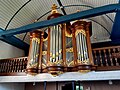 Tsjerke fan Duerswâld, oargel II.jpg 3,264 × 2,448; 1.86 MB
-
 Tsjerke fan Duerswâld.jpg 2,524 × 1,683; 1.49 MB


