Category:Kerkhof Ranum
Jump to navigation
Jump to search
| Object location | | View all coordinates using: OpenStreetMap |
|---|
 | |||||
| Upload media | |||||
| Instance of | |||||
|---|---|---|---|---|---|
| Location | Het Hogeland, Groningen, Netherlands | ||||
| Street address |
| ||||
| Heritage designation |
| ||||
 | |||||
Nederlands: Kerkhof van Ranum
|
This is a category about rijksmonument number 39049
|
| Address |
|
Media in category "Kerkhof Ranum"
The following 14 files are in this category, out of 14 total.
-
 Kerkhof - Ranum - 20184513 - RCE.jpg 1,188 × 1,200; 446 KB
-
 Kerkhof - Ranum - 20184514 - RCE.jpg 1,195 × 1,200; 450 KB
-
 Kerkhof Ranum (1).jpg 4,896 × 2,305; 12.61 MB
-
 Kerkhof Ranum (2).jpg 4,548 × 3,032; 14.79 MB
-
 Kerkhof Ranum (3).jpg 4,896 × 2,754; 15.54 MB
-
 Kerkhof Ranum (4).jpg 4,896 × 3,264; 15.24 MB
-
 Kerkhof Ranum (5).jpg 4,896 × 3,264; 17.36 MB
-
 Kerkhof Ranum (6).jpg 4,896 × 3,264; 17.29 MB
-
 Kerkhof Ranum (7).jpg 4,896 × 3,264; 19.35 MB
-
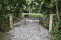
 Ranum - kerkhof - entree.jpg 5,962 × 3,975; 22.54 MB
-
 Ranum - kerkhof - graf.jpg 6,000 × 3,375; 16.81 MB
-
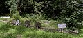
 Ranum - kerkhof - graven.jpg 6,000 × 4,000; 18.11 MB
-
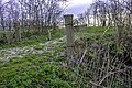
 Ranum - kerkhof - pad naar kerkhof.jpg 2,192 × 3,288; 4.25 MB
-
 Ranum - kerkhof vanaf wierde.jpg 5,174 × 3,449; 12.12 MB

.jpg)
.jpg)
.jpg)
.jpg)
.jpg)
.jpg)
.jpg)


