Category:Kerkstraat 23, Weurt
Jump to navigation
Jump to search
| Object location | | View all coordinates using: OpenStreetMap |
|---|
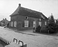
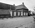
farmhouse in Beuningen, Netherlands _Rijksmonument_9552_Kerkstraat_23_(straatzijde).JPG) | |||||
| Upload media | |||||
| Instance of | |||||
|---|---|---|---|---|---|
| Location | Weurt, Gelderland, Netherlands | ||||
| Street address |
| ||||
| Located on street |
| ||||
| Heritage designation |
| ||||
 | |||||
|
This is a category about rijksmonument number 9552
|
| Address |
|
Media in category "Kerkstraat 23, Weurt"
The following 13 files are in this category, out of 13 total.
-
 Aanzicht - Weurt - 20255482 - RCE.jpg 1,200 × 804; 193 KB
-
 Aanzicht - Weurt - 20255484 - RCE.jpg 1,200 × 960; 217 KB
-
 Achtergevel - Weurt - 20255492 - RCE.jpg 1,200 × 965; 341 KB
-
 Detail voorgevel - Weurt - 20255487 - RCE.jpg 1,200 × 957; 261 KB
-
 Detail zijgevel - Weurt - 20255489 - RCE.jpg 1,200 × 958; 247 KB
-
 Exterieur - Weurt - 20255486 - RCE.jpg 1,200 × 968; 199 KB
-
 Exterieur - Weurt - 20255490 - RCE.jpg 1,200 × 963; 249 KB
-
 Gevel - Weurt - 20255488 - RCE.jpg 1,200 × 962; 334 KB
-
 Voorgevel - Weurt - 20255483 - RCE.jpg 1,200 × 965; 277 KB
-
 Voorgevel - Weurt - 20255485 - RCE.jpg 1,200 × 959; 254 KB
-
 Weurt (Beuningen) Rijksmonument 9552 Kerkstraat 23 (straatzijde).JPG 3,648 × 2,736; 4.27 MB
-
 Weurt (Beuningen) Rijksmonument 9552 Kerkstraat 23 (voorhuis).JPG 3,648 × 2,736; 4.25 MB
-
 Zijgevel - Weurt - 20255491 - RCE.jpg 1,200 × 960; 343 KB


_Rijksmonument_9552_Kerkstraat_23_(voorhuis).JPG)
