Category:Kerkstraat 34, 's-Hertogenbosch
Jump to navigation
Jump to search
| Object location | | View all coordinates using: OpenStreetMap |
|---|
house in 's-Hertogenbosch, Netherlands  | |||||
| Upload media | |||||
| Instance of | |||||
|---|---|---|---|---|---|
| Location | 's-Hertogenbosch, North Brabant, Netherlands | ||||
| Street address |
| ||||
| Located on street | |||||
| Heritage designation |
| ||||
 | |||||
|
This is a category about rijksmonument number 21678
|
| Address |
|
Media in category "Kerkstraat 34, 's-Hertogenbosch"
The following 12 files are in this category, out of 12 total.
-
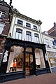
 's-Hertogenbosch Rijksmonument 21678 Kerkstraat 34, 36.JPG 2,736 × 3,648; 3.24 MB
-
 Benedendeel voorgevel - 's-Hertogenbosch - 20110194 - RCE.jpg 1,192 × 1,200; 332 KB
-
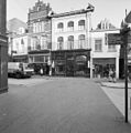
 Centrum, 5211 's-Hertogenbosch, Netherlands - panoramio (95).jpg 3,264 × 4,896; 4.55 MB
-
 Exterieur VOORGEVEL - 's-Hertogenbosch - 20286083 - RCE.jpg 967 × 1,200; 238 KB
-
 Firma N. Glaudemans en Zn.jpg 643 × 515; 125 KB
-
 Overzicht - 's-Hertogenbosch - 20110195 - RCE.jpg 818 × 1,200; 216 KB
-
 Overzicht - 's-Hertogenbosch - 20110197 - RCE.jpg 788 × 1,200; 214 KB
-
 Overzicht van de voorgevel van het winkelpand - 's-Hertogenbosch - 20381362 - RCE.jpg 1,195 × 1,200; 269 KB
-
 Overzicht van de voorgevels van de winkelpanden - 's-Hertogenbosch - 20381363 - RCE.jpg 1,200 × 1,200; 221 KB
-
-

-
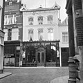 Voorgevel - 's-Hertogenbosch - 20110193 - RCE.jpg 1,198 × 1,200; 328 KB

.jpg)


