Category:Kerkstraat 59, Zuidbroek
Jump to navigation
Jump to search
| Object location | | View all coordinates using: OpenStreetMap |
|---|
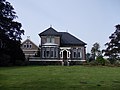
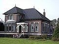
villa in Menterwolde, Netherlands  | |||||
| Upload media | |||||
| Instance of | |||||
|---|---|---|---|---|---|
| Part of | |||||
| Location | Zuidbroek, Midden-Groningen, Groningen, Netherlands | ||||
| Street address |
| ||||
| Located on street |
| ||||
| Heritage designation |
| ||||
 | |||||
|
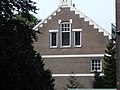
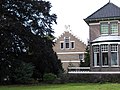
This is a category about rijksmonumentcomplex number 520961
|
Woonhuis
|
This is a category about rijksmonument number 520962
|
Schuur
|
This is a category about rijksmonument number 520963
|
Schuur
|
This is a category about rijksmonument number 520964
|
| Address |
|
Media in category "Kerkstraat 59, Zuidbroek"
The following 6 files are in this category, out of 6 total.
-
 Boerderij 1920 Zuidbroek.jpg 3,648 × 2,736; 2.22 MB
-
 Boerderij Zuidbroek.jpg 3,648 × 2,736; 2.19 MB
-
 Súdbroek, Tsjerkestrjitte 59.jpg 3,344 × 2,227; 2.96 MB
-
 Woonhuis Zuidbroek 1.jpg 3,648 × 2,736; 2.33 MB
-
 Woonhuis Zuidbroek 2.jpg 3,648 × 2,736; 2.19 MB
-
 Woonhuis Zuidbroek 3.jpg 3,648 × 2,736; 2.25 MB


