Category:Kerkstraat 6, Bredevoort
Jump to navigation
Jump to search
| Object location | | View all coordinates using: OpenStreetMap |
|---|
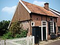
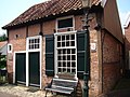
farmhouse in Aalten, Netherlands  | |||||
| Upload media | |||||
| Instance of | |||||
|---|---|---|---|---|---|
| Location | Bredevoort, Aalten, Gelderland, Netherlands | ||||
| Heritage designation |
| ||||
 | |||||
|
This is a category about rijksmonument number 6862
|
| Address |
|
Media in category "Kerkstraat 6, Bredevoort"
The following 7 files are in this category, out of 7 total.
-
 Bredevoort jansenshuusken.jpg 3,264 × 2,448; 1.98 MB
-
 Exterieur VOORGEVEL, LINKER ZIJGEVEL - Bredevoort - 20339577 - RCE.jpg 1,195 × 1,200; 319 KB
-
 Jansenshuusken bredevoort 085.JPG 3,264 × 2,448; 1.96 MB
-
 Kerkstr. 6, voor- en zijgevel - Bredevoort - 20041792 - RCE.jpg 1,200 × 806; 210 KB
-
 Kerkstraat 6, linker zijgevel - Bredevoort - 20041794 - RCE.jpg 1,197 × 1,200; 293 KB
-
 Kerkstraat 6, overzicht - Bredevoort - 20041793 - RCE.jpg 1,199 × 1,200; 340 KB
-
 Kerkstraat 6, rechter zijgevel - Bredevoort - 20041795 - RCE.jpg 1,194 × 1,200; 342 KB


