Category:Khardung La
Aller à la navigation
Aller à la recherche
བོད་ཡིག: མཁར་རྫོང་ལ (aka འཁར་དོང་ལ) / མཁར་གདོང་ལ་
མཁར་རྫོང་ = fortress, fort
མཁར་རྫོང་ = fortress, fort
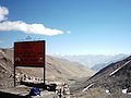
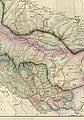
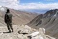
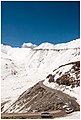
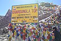
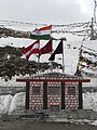
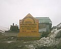
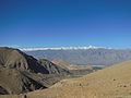
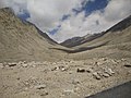
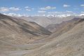
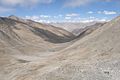
Khardung La - La means pass in Tibetan - (elevation 5359 m) is a high mountain pass located in Ladakh, India. The local pronunciation is "Khardong La" or "Khardzong La," but, as with most names in Ladakh, the romanised spelling varies. The pass on the Ladakh Range lies north of Leh and is the gateway to the Shyok and Nubra valleys. The Siachen Glacier lies partway up the latter valley. Built in 1976, it was opened to motor vehicles in 1988 and has since seen many automobile, motorbike and mountain biking expeditions.
| Position de l'objet | | Voir toutes les coordonnées en utilisant : OpenStreetMap |
|---|
Mountain pass in Ladakh, India ,_Ladakh,_North_India.jpg) | |||||
| Téléverser des médias | |||||
| Nature de l’élément | |||||
|---|---|---|---|---|---|
| Lieu |
| ||||
| Chaîne de montagnes | |||||
| Altitude |
| ||||
 | |||||
Sous-catégories
Cette catégorie comprend 2 sous-catégories, dont les 2 ci-dessous.
K
U
- U-shaped valley, Leh (15 F)
Média dans la catégorie « Khardung La »
Cette catégorie comprend 68 fichiers, dont les 68 ci-dessous.
-
 17 kardong la.jpg 1 791 × 1 343 ; 448 kio
-
 3 Peak(leh-khardungla).jpg 6 000 × 4 000 ; 6,38 Mio
-
 ActualDisplayBoardAtKhardungLa.JPG 3 072 × 2 304 ; 1,17 Mio
-
 Highway (38053570).jpeg 2 048 × 1 365 ; 292 kio
-
 Himank - God is One.jpg 1 719 × 1 352 ; 434 kio
-
 Hindutagh-pass-aksai-chin-center2-1873.jpg 1 386 × 1 980 ; 409 kio
-

-
 Indus River Valley from Khardung La (pass), Ladakh, North India.jpg 3 072 × 2 048 ; 5,3 Mio
-
 Kardhung La (27988829614).jpg 4 120 × 2 648 ; 4,03 Mio
-
 Kardhung La (27988837344).jpg 4 928 × 3 264 ; 17,79 Mio
-
 Kardhung La (27989956713).jpg 4 470 × 2 669 ; 10,57 Mio
-
 Kardhung La (28321793350).jpg 3 417 × 1 964 ; 6,88 Mio
-
 Kardhung La (28321901530).jpg 3 160 × 1 845 ; 3,57 Mio
-
 Khardung La (mountain pass), Ladakh, North India.jpg 3 072 × 2 048 ; 5,33 Mio
-
 Khardung La (pass), Checkpoint, Army, Ladakh, North India.jpg 3 072 × 2 048 ; 5,46 Mio
-
 Khardung La (pass), Checkpoint, Ladakh, India, Himalaya.jpg 3 072 × 2 048 ; 6,04 Mio
-
 Khardung La (pass), Checkpoint, Ladakh, North India.jpg 3 072 × 2 048 ; 5,41 Mio
-
 Khardung La (pass), Indus Valley, Ladakh, North India.jpg 3 072 × 2 048 ; 5,59 Mio
-
 Khardung La (pass), Ladakh Range, North India, Himalaya.jpg 3 072 × 2 048 ; 5,74 Mio
-
 Khardung La (pass), Ladakh, North India.jpg 3 072 × 2 048 ; 5,24 Mio
-
 Khardung La (pass), Mountains, Indus River Valley, Ladakh, North India, Himalayas.jpg 3 072 × 2 048 ; 5,1 Mio
-
 Khardung La - Highest Souvenir Shop in the World sign.jpg 1 024 × 768 ; 411 kio
-
 Khardung La -JK08661- (34887183791).jpg 2 642 × 3 922 ; 1,43 Mio
-
 Khardung La ladakh 001.jpg 3 640 × 2 568 ; 2,08 Mio
-
 Khardung La Memorial.jpg 4 608 × 3 072 ; 4,08 Mio
-
 Khardung La office and shop 01.jpg 1 024 × 558 ; 424 kio
-
 Khardung La Panorama.jpg 11 756 × 1 338 ; 18,62 Mio
-
 Khardung La Pass - panoramio.jpg 2 048 × 1 536 ; 847 kio
-
 Khardung La pass in the middle and heavy trucks - panoramio.jpg 2 592 × 1 944 ; 2,13 Mio
-
 Khardung La Pass, highest road in the world (2563941837).jpg 3 456 × 2 304 ; 3,26 Mio
-
 Khardung La Top.jpg 1 024 × 715 ; 486 kio
-
 Khardung La with MC Outdoors Riders Jana Fesslova and Radek Kriegler.jpg 2 000 × 1 500 ; 1,18 Mio
-
 Khardung La, Ladakh.jpg 4 272 × 2 848 ; 1,63 Mio
-
 Khardung La.jpg 351 × 233 ; 64 kio
-
 Khardung la.jpg 912 × 606 ; 111 kio
-
 KHARDUNG-LA PASS.jpg 3 120 × 4 160 ; 1,49 Mio
-
 Khardungla Pass.JPG 3 072 × 2 304 ; 2,79 Mio
-
 Khardungla Tigers.jpg 780 × 1 040 ; 129 kio
-
 Khardungla Top, Ladakh.JPG 6 000 × 4 000 ; 6,48 Mio
-
 Khardungla Top.JPG 3 264 × 2 448 ; 3,21 Mio
-
 KhardungLa, Ladakh.jpg 1 200 × 1 600 ; 1 009 kio
-
 KhardungLa.jpg 640 × 512 ; 51 kio
-
 Khardungla18380.jpg 4 288 × 2 848 ; 1,4 Mio
-
 KhardungLa2.jpg 640 × 512 ; 48 kio
-
 KhardungLa3.jpg 1 728 × 1 152 ; 943 kio
-
 KhardungLa4B.jpg 349 × 566 ; 88 kio
-
 Khardunglasign18380.jpg 4 288 × 2 848 ; 1,48 Mio
-
 KhardungLaToLeh.png 972 × 1 478 ; 2,02 Mio
-
 KhardunglaTop-1.jpg 2 048 × 1 536 ; 755 kio
-
 Landscape237.jpg 4 608 × 3 456 ; 6,51 Mio
-
 Landscape999.jpg 4 608 × 3 456 ; 6,29 Mio
-
Leh to Khardung La on bike.webm 5 min 9 s, 1 280 × 720 ; 181,17 Mio
-
 Map of Tibet and Pangong Lake in 1873 from Hindutagh-pass-aksai-chin-center2-1873 (cropped).jpg 1 130 × 1 131 ; 205 kio
-
 Mountain biking Ladahk, India 43037992 624b2b553f.jpg 1 080 × 720 ; 92 kio
-
 Mountains and clouds in leh.jpg 4 160 × 3 120 ; 2,41 Mio
-
 Mountains show and clouds.jpg 4 160 × 3 120 ; 3,15 Mio
-
 Peak above Khardung La.jpg 768 × 1 024 ; 360 kio
-
 Prayer flags (lots of them) at the Khardung La (10001182746).jpg 5 184 × 3 456 ; 13,43 Mio
-
 Robin Accentor, Khardung La, Ladakh, India.jpg 1 024 × 678 ; 200 kio
-
 Elena 6 oct 2009.JPG 1 944 × 2 592 ; 2,84 Mio
-
 Saser Muztagh from Khardung La 2.jpg 2 048 × 1 365 ; 417 kio
-
 Saser Muztagh from Khardung La.jpg 2 048 × 1 365 ; 491 kio
-
 Shoyok and Nubra Valley map.jpg 1 024 × 768 ; 585 kio
-
 Stuck at 16,000ft, Khardung La Pass (2564772014).jpg 3 456 × 2 304 ; 2,95 Mio
-
 Temple @ 18,379 ft - Indian Army.jpg 5 456 × 3 064 ; 4,47 Mio
-
 The world's highest motorable claim- Khardung La Pass.jpg 3 064 × 5 456 ; 4,07 Mio
-
 World Higest Motorable Road Of World - Khardung La.jpg 5 456 × 3 064 ; 5,53 Mio
-
 मायटी खरदुंगला.jpg 1 040 × 780 ; 129 kio

.jpg)

.jpeg)


,_Ladakh,_North_India.jpg)
.jpg)
.jpg)
.jpg)
.jpg)
.jpg)
,_Checkpoint,_Army,_Ladakh,_North_India.jpg)
,_Checkpoint,_Ladakh,_India,_Himalaya.jpg)
,_Checkpoint,_Ladakh,_North_India.jpg)
,_Indus_Valley,_Ladakh,_North_India.jpg)
,_Ladakh_Range,_North_India,_Himalaya.jpg)
,_Ladakh,_North_India.jpg)
,_Mountains,_Indus_River_Valley,_Ladakh,_North_India,_Himalayas.jpg)

.jpg)


.jpg)


.jpg)


_at_the_Khardung_La_(10001182746).jpg)


.jpg)


