Category:Kirche Fördergersdorf
Jump to navigation
Jump to search
| Object location | | View all coordinates using: OpenStreetMap |
|---|
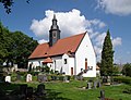
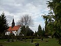
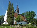
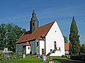
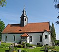
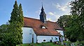
church building in Tharandt, Saxony, Germany  _Dorfkirche_zum_Altar.jpg) | |||||
| Upload media | |||||
| Instance of | |||||
|---|---|---|---|---|---|
| Location | Fördergersdorf, Tharandt, Verwaltungsgemeinschaft Tharandt, Sächsische Schweiz-Osterzgebirge, Saxony, Germany | ||||
| Street address |
| ||||
| Heritage designation | |||||
| Inception |
| ||||
 | |||||
Subcategories
This category has the following 3 subcategories, out of 3 total.
F
- Friedhof Fördergersdorf (17 F)
P
- Pfarrhof Fördergersdorf (11 F)
Media in category "Kirche Fördergersdorf"
The following 24 files are in this category, out of 24 total.
-
 20140531010DR Fördergersdorf (Tharandt) Dorfkirche.jpg 3,190 × 2,448; 3.68 MB
-
 20140531015DR Fördergersdorf (Tharandt) Dorfkirche.jpg 2,854 × 2,322; 2.92 MB
-
 20140531020DR Fördergersdorf (Tharandt) Dorfkirche Pfarrhaus.jpg 3,059 × 2,298; 3.49 MB
-
 20140531025DR Fördergersdorf (Tharandt) Dorfkirche Pfarrhaus.jpg 3,073 × 2,153; 3.38 MB
-
 FriedhofKircheFoerdergersdorf280310FotoAndreKaiser.JPG 576 × 432; 56 KB
-
 Fördergersdorf-Kirche-01.jpg 3,436 × 2,624; 2.92 MB
-
 Fördergersdorf-Kirche-02.jpg 3,444 × 2,549; 2.33 MB
-
 Fördergersdorf-Kirche-03.jpg 3,179 × 2,384; 3.17 MB
-
 Fördergersdorf-Kirche-04.jpg 2,736 × 3,085; 1.96 MB
-
 Fördergersdorf-Kirche-05.jpg 3,570 × 3,153; 2.98 MB
-
 Fördergersdorf-Kirche-06.jpg 3,590 × 3,170; 2.5 MB
-
 Fördergersdorf-Kirche-07.jpg 3,648 × 2,736; 2.09 MB
-
 Fördergersdorf-Kirche-08.jpg 2,554 × 4,468; 2.29 MB
-
 Fördergersdorf-Kirche-09.jpg 2,537 × 3,383; 1.66 MB
-
 Fördergersdorf-Kirche-10.jpg 2,469 × 3,292; 2.19 MB
-
 MittlereGlockeKircheFoerdergersdorfFotoAKaiser.JPG 900 × 1,200; 123 KB
-
 JakobswegHeiligerWegPfarrgasseSchilderDetail270321FotoAKaiser.jpg 867 × 700; 205 KB
-
 Kirche Fördergersdorf Nordansicht 2021.jpg 4,000 × 2,250; 3.55 MB
-
 KircheFoerdergersdorf071208FotoAndreKaiser.jpg 4,288 × 2,848; 2.07 MB
-
 KircheFoerdergersdorf100509FotoAndreKaiser.JPG 948 × 1,424; 175 KB
-
 MitelalterAussenwandbildKircheFoerdergersdorf1995FotoAKaiser.jpg 1,184 × 768; 422 KB
-
 RomanischesFensterKircheFoerdergersdorf1995FotoAKaiser.jpg 816 × 1,056; 409 KB
-
 RomanischesPortalKircheFoerdergersdorf1995FotoAKaiser.jpg 816 × 1,152; 423 KB
-
 StempelSaechsJakobswegFoerdergersdorf020612AKaiser.jpg 512 × 448; 22 KB
_Dorfkirche.jpg)
_Dorfkirche.jpg)
_Dorfkirche_Pfarrhaus.jpg)
_Dorfkirche_Pfarrhaus.jpg)


