Category:Kirche Hohnstädt
Jump to navigation
Jump to search
| Object location | | View all coordinates using: OpenStreetMap |
|---|
church building in Grimma, Germany _-_Dorfkirche.jpg) | |||||
| Upload media | |||||
| Instance of | |||||
|---|---|---|---|---|---|
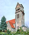
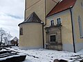
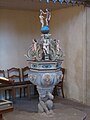
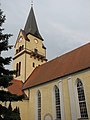
| Location | Hohnstädt, Grimma, Landkreis Leipzig, Saxony, Germany | ||||
| Street address |
| ||||
| Heritage designation | |||||
| Inception |
| ||||
 | |||||
| (Wikidata) |
Media in category "Kirche Hohnstädt"
The following 19 files are in this category, out of 19 total.
-
 20090321070DR Hohnstädt (Grimma) Kirche.jpg 1,630 × 2,528; 4.47 MB
-
 20090321075DR Hohnstädt (Grimma) Kirche.jpg 2,227 × 2,680; 6.04 MB
-
 21378-Hohnstädt-1919-Blick auf Hohnstädt, Kirche-Brück & Sohn Kunstverlag.jpg 1,543 × 1,000; 454 KB
-
 Dorfkirche (Hohnstädt) 01.jpg 4,608 × 3,456; 3.52 MB
-
 Dorfkirche (Hohnstädt) 02.jpg 3,024 × 4,032; 4.84 MB
-
 Dorfkirche (Hohnstädt) 03.jpg 4,032 × 3,024; 3.83 MB
-
 Dorfkirche (Hohnstädt) 04.jpg 3,024 × 4,032; 3.78 MB
-
 Dorfkirche (Hohnstädt) 05.jpg 4,032 × 3,024; 6.1 MB
-
 Grimma-Hohnstädt Kirche.jpg 5,172 × 3,879; 9.88 MB
-
 HohnstädtKirche1.JPG 3,648 × 2,736; 1.89 MB
-
 HohnstädtKirche2.JPG 2,736 × 3,648; 2.38 MB
-
 HohnstädtKirche3.JPG 3,648 × 2,736; 2.07 MB
-
 Kirche-Hohnstaedt-1.jpg 2,048 × 1,536; 826 KB
-
 Kirche-Hohnstaedt-2.jpg 2,048 × 1,536; 758 KB
-
 Kirche-Hohnstaedt-3.jpg 1,536 × 2,048; 802 KB
-
 Kirche-Hohnstaedt-4.jpg 1,536 × 2,048; 807 KB
-
 Kirche-Hohnstaedt-5.jpg 1,536 × 2,048; 756 KB
-
 Kirche-Hohnstaedt-6.jpg 1,536 × 2,048; 838 KB
-
 Schillerstr 15 (Hohnstädt) - Dorfkirche.jpg 4,032 × 3,024; 4.83 MB
_Kirche.jpg)
_Kirche.jpg)

_01.jpg)
_02.jpg)
_03.jpg)
_04.jpg)
_05.jpg)


