Category:Kirche Nordgermersleben
Jump to navigation
Jump to search
| Object location | | View all coordinates using: OpenStreetMap |
|---|
church building in Hohe Börde, Germany  | |||||
| Upload media | |||||
| Instance of | |||||
|---|---|---|---|---|---|
| Named after | |||||
| Location | Nordgermersleben, Hohe Börde, Börde, Saxony-Anhalt, Germany | ||||
| Heritage designation | |||||
 | |||||
Media in category "Kirche Nordgermersleben"
The following 6 files are in this category, out of 6 total.
-
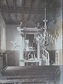 Blech Kirche Nordgermersleben innen 1906.JPG 3,456 × 4,608; 3.33 MB
-
 Blech Nordgermersleben.JPG 511 × 670; 108 KB
-
 Nordgermersleben 1904 .jpg 4,147 × 2,904; 3.64 MB
-
 Nordgermersleben evangelische Kirche 01.jpg 6,016 × 4,000; 10.79 MB
-
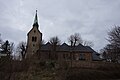 Nordgermersleben evangelische Kirche 02.jpg 6,016 × 4,000; 10.7 MB
-
 Nordgermersleben Kirche.jpg 2,000 × 1,500; 1.21 MB


