Category:Kirche Schorbus
Jump to navigation
Jump to search
| Object location | | View all coordinates using: OpenStreetMap |
|---|
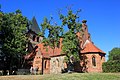
church building in Brandenburg state, Germany  | |||||
| Upload media | |||||
| Instance of | |||||
|---|---|---|---|---|---|
| Location | Schorbus, Drebkau, Spree-Neiße District, Brandenburg, Germany | ||||
| Heritage designation | |||||
 | |||||
This is the category of the Brandenburger Baudenkmal (cultural heritage monument) with the ID 09125246 (Wikidata)
|
Subcategories
This category has only the following subcategory.
I
- Interior of Kirche Schorbus (4 F)
Media in category "Kirche Schorbus"
The following 6 files are in this category, out of 6 total.
-
 Kirche schorbus 2020-05-22 2.jpg 2,736 × 3,648; 3.94 MB
-
 Kirche schorbus 2020-05-22 3.jpg 3,648 × 2,736; 3.36 MB
-
 Kirche schorbus 2020-05-22 4.jpg 3,648 × 2,736; 3.46 MB
-
 Kirche schorbus 2020-05-22.jpg 2,736 × 3,648; 2.77 MB
-
 Skjarbošc Cyrkej 1.jpg 2,500 × 1,667; 3.09 MB
-
 Skjarbošc Cyrkej 6.jpg 2,500 × 1,667; 3.15 MB


