Category:Kirche im Walde
Jump to navigation
Jump to search
| Object location | | View all coordinates using: OpenStreetMap |
|---|
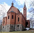
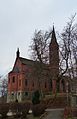
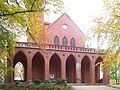
Deutsch: Kirche im Walde
Polski: Kościół w Lesie
church building in Heringsdorf, Germany  | |||||
| Upload media | |||||
| Instance of | |||||
|---|---|---|---|---|---|
| Location | Heringsdorf, Vorpommern-Greifswald District, Mecklenburg-Western Pomerania, Germany | ||||
| Architectural style | |||||
| Architect | |||||
| Heritage designation | |||||
 | |||||
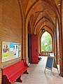
Subcategories
This category has only the following subcategory.
I
- Interior of Kirche im Walde (5 F)
Media in category "Kirche im Walde"
The following 16 files are in this category, out of 16 total.
-
 Heringsdorf (Usedom), church.jpg 3,780 × 2,835; 7.2 MB
-
 Heringsdorf (Usedom), Kirche im Walde.jpg 2,834 × 3,780; 6.45 MB
-
 Heringsdorf (Usedom), Kirche.jpg 2,657 × 3,543; 6.14 MB
-
 Heringsdorf church.jpg 2,358 × 3,536; 5.3 MB
-
 Heringsdorf Kirche 2010-03.15.jpg 2,592 × 1,944; 2.8 MB
-
 Heringsdorf Kirche Chor.jpg 2,681 × 2,596; 3.28 MB
-
 Heringsdorf Kirche Nordost.jpg 2,568 × 3,972; 7.09 MB
-
 Heringsdorf Kirche Süd.JPG 4,000 × 3,000; 3.59 MB
-
 Heringsdorf Kirche Westseite.jpg 3,546 × 2,986; 10.48 MB
-
 Heringsdorf Kirche.jpg 768 × 1,024; 267 KB
-
 Heringsdorf, Germany - panoramio (5).jpg 3,240 × 4,320; 4.91 MB
-
 HeringsdorfKirche.jpg 2,438 × 1,980; 4.42 MB
-
 HeringsdorfKircheVorhalle.jpg 2,686 × 2,020; 4.4 MB
-
 Kirchen rückseite - panoramio (1).jpg 4,320 × 3,240; 5.97 MB
-
 Kirchen vorderseite - panoramio.jpg 3,309 × 4,809; 6.9 MB
-
 Vor der Kirche - panoramio.jpg 3,016 × 2,235; 1 MB
,_church.jpg)
,_Kirche_im_Walde.jpg)
,_Kirche.jpg)


.jpg)


.jpg)


Categories:
- Buildings in Heringsdorf (Usedom)
- Gothic Revival brick churches in Landkreis Vorpommern-Greifswald
- 1840s brick churches in Mecklenburg-Vorpommern
- Built in Mecklenburg-Vorpommern in 1848
- Churches in Germany built in 1848
- Cultural heritage monuments in Heringsdorf
- Churches in Propstei Pasewalk
- Rudolf-Breitscheid-Straße (Heringsdorf)
- Lutheran churches in Landkreis Vorpommern-Greifswald