Category:Klapstraat 17, Vreeland
Jump to navigation
Jump to search
| Object location | | View all coordinates using: OpenStreetMap |
|---|
 | |||||
| Upload media | |||||
| Instance of |
| ||||
|---|---|---|---|---|---|
| Location | Vreeland, Utrecht, Netherlands | ||||
| Street address |
| ||||
| Located on street |
| ||||
| Heritage designation |
| ||||
 | |||||
|
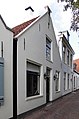
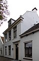
This is a category about rijksmonument number 26137
|
| Address |
|
Media in category "Klapstraat 17, Vreeland"
The following 5 files are in this category, out of 5 total.
-
 Aanzicht - Vreeland - 20247216 - RCE.jpg 948 × 1,200; 214 KB
-
 Overzicht - Vreeland - 20247207 - RCE.jpg 795 × 1,200; 199 KB
-
 Voorgevel - Vreeland - 20247221 - RCE.jpg 805 × 1,200; 211 KB
-
 Vreeland - Klapstraat 15 RM26135.JPG 3,012 × 4,545; 883 KB
-
 Vreeland - Klapstraat 17-19 RM26136-26137.JPG 2,889 × 4,452; 803 KB


