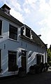
Category:Klapstraat 2, Vreeland
Jump to navigation
Jump to search
| Object location | | View all coordinates using: OpenStreetMap |
|---|
house in Stichtse Vecht, Netherlands  | |||||
| Upload media | |||||
| Instance of | |||||
|---|---|---|---|---|---|
| Location | Vreeland, Utrecht, Netherlands | ||||
| Street address |
| ||||
| Located on street |
| ||||
| Heritage designation |
| ||||
 | |||||
|
This is a category about rijksmonument number 26141
|
| Address |
|
Media in category "Klapstraat 2, Vreeland"
The following 3 files are in this category, out of 3 total.
-
 Deur - Vreeland - 20247209 - RCE.jpg 805 × 1,200; 167 KB
-
 Voorgevel - Vreeland - 20247208 - RCE.jpg 1,200 × 799; 230 KB
-
 Vreeland - Klapstraat 2 RM26141.JPG 2,710 × 4,455; 697 KB

