Category:Klosterhof (Walberberg)
Jump to navigation
Jump to search
| Object location | | View all coordinates using: OpenStreetMap |
|---|
| NO WIKIDATA ID FOUND! Search for Klosterhof (Walberberg) on Wikidata | |
| Upload media |
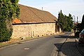
| This category shows a heritage building in Germany, located in the North Rhine-Westphalian city Bornheim (Rheinland) (no. 241). |
Media in category "Klosterhof (Walberberg)"
The following 3 files are in this category, out of 3 total.
-
 Walberberg Frongasse 37, hier Hanrathstr. mit d. Südseite.jpg 5,760 × 3,840; 16.31 MB
-
 Walberberg Frongasse 37, Klosterhof.jpg 5,160 × 3,656; 12.14 MB
-
 Walberberg Klosterhof Informationstafel.jpg 3,469 × 3,459; 2.51 MB


