Category:Klostermansfeld
Jump to navigation
Jump to search
municipality in the Mansfeld-Südharz district, Saxony-Anhalt, Germany    | |||||
| Upload media | |||||
| Instance of |
| ||||
|---|---|---|---|---|---|
| Location | Mansfelder Grund-Helbra, Mansfeld-Südharz, Saxony-Anhalt, Germany | ||||
| Population |
| ||||
| Area |
| ||||
| Elevation above sea level |
| ||||
 | |||||
Subcategories
This category has the following 7 subcategories, out of 7 total.
Media in category "Klostermansfeld"
The following 24 files are in this category, out of 24 total.
-
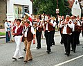 Helbra, der Klostermansfelder Musikverein.jpg 1,923 × 1,520; 894 KB
-
 KLG 4478 Klostermansfeld.jpg 6,016 × 3,384; 9.33 MB
-
 Klostermannsfeld - 50Pf. 1920.jpg 1,102 × 1,443; 848 KB
-
 Klostermansfeld Dorfgemeinschaftshaus.jpg 2,200 × 1,650; 820 KB
-
 Klostermansfeld Feuerwehr.jpg 2,200 × 1,650; 1,009 KB
-
 Klostermansfeld Grundschule.jpg 2,200 × 1,650; 1.17 MB
-
 Klostermansfeld, die Ernst-Thälmann-Straße.jpg 2,490 × 1,685; 1.43 MB
-
 Klostermansfeld, die Schulstraße.jpg 2,551 × 1,701; 1.22 MB
-
 Klostermansfeld, die Sparkasse.jpg 2,490 × 1,698; 1.65 MB
-
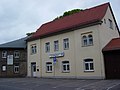
 Klostermansfeld, Haus Bahnhofstraße 12.jpg 4,154 × 2,846; 4.36 MB
-
 Klostermansfeld, Haus Bahnhofstraße 8, Rotbuche.jpg 4,272 × 2,848; 8.82 MB
-
 Klostermansfeld, Haus Bahnhofstraße 9.jpg 4,272 × 2,848; 4.49 MB
-
 Klostermansfeld, Häuserzeile in der Bahnhofstraße.jpg 4,272 × 2,848; 5.3 MB
-
 Klostermansfeld, the dump "Lichtloch 81".jpg 2,551 × 1,701; 3.24 MB
-
 Klostermansfeld, the dump of the Zirkelschacht.jpg 2,657 × 1,772; 1.09 MB
-
 Klostermansfeld, the southern part of the Neue Straße und the water tower.jpg 2,551 × 1,701; 706 KB
-
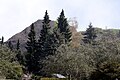
 Klostermansfeld, view to the village.jpg 2,638 × 1,584; 878 KB
-
 Klosterrmansfeld, Schacht Lichtloch 81.jpg 2,551 × 1,701; 1.19 MB
-
 LKM V10C 250308.jpg 2,200 × 1,650; 1.14 MB
-
 Ortswappen.png 212 × 237; 107 KB
-
 OuK 12350 (01).jpg 2,154 × 1,423; 1.55 MB
-
 OuK 12350 (02).jpg 2,200 × 1,650; 1.11 MB
-
 UEF Lokalbahn 98 812 in Einzelteilen ohne Kessel in Klostermansfeld, September 2021.jpg 5,892 × 3,928; 18.71 MB
-
 Wappen Klostermansfeld.png 590 × 660; 63 KB


.jpg)
.jpg)
