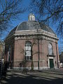
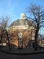
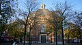
Category:Koepelkerk, Arnhem
Jump to navigation
Jump to search
| Object location | | View all coordinates using: OpenStreetMap |
|---|
church building in Arnhem, Netherlands  | |||||
| Upload media | |||||
| Instance of | |||||
|---|---|---|---|---|---|
| Location | Arnhem, Gelderland, Netherlands | ||||
| Street address |
| ||||
| Located on street | |||||
| Architect | |||||
| Heritage designation |
| ||||
| Inception |
| ||||
| Significant event |
| ||||
 | |||||
|
This is a category about rijksmonument number 8331
|
| Address |
|
Media in category "Koepelkerk, Arnhem"
The following 31 files are in this category, out of 31 total.
-
 2018-01-20 Arnhem Koepelkerk.jpg 4,592 × 3,448; 8.51 MB
-
 8331 arnhem - Koepelkerk.jpg 4,387 × 3,390; 14.39 MB
-
 Arnhem-Koepelkerk.JPG 4,000 × 3,000; 4.66 MB
-
 Dome Church (1837) (2181345020).jpg 1,011 × 675; 353 KB
-
 Doorsnede in de verzameling C.H.Peters - Arnhem - 20024827 - RCE.jpg 1,200 × 883; 217 KB
-
 Exterieur naar het noorden - Arnhem - 20024828 - RCE.jpg 965 × 1,200; 322 KB
-
 Exterieur naar het oosten - Arnhem - 20024829 - RCE.jpg 961 × 1,200; 238 KB
-
 Interieur - Arnhem - 20024830 - RCE.jpg 954 × 1,200; 170 KB
-
 Interieur met orgel - Arnhem - 20024837 - RCE.jpg 815 × 1,200; 247 KB
-
 Interieur met preekstoel en orgel - Arnhem - 20024831 - RCE.jpg 944 × 1,200; 185 KB
-
 Interieur van de koepel - Arnhem - 20024836 - RCE.jpg 1,200 × 959; 218 KB
-
 Interieur, aanzicht orgel, orgelnummer 101 - Arnhem - 20368930 - RCE.jpg 857 × 1,200; 178 KB
-
 Interieur, cassettenkoepel neoclassicistische kerk - Arnhem - 20369634 - RCE.jpg 1,200 × 995; 176 KB
-
 Jansplein overzicht - Arnhem - 20025381 - RCE.jpg 1,200 × 961; 298 KB
-
 Koepelkerk Arnhem 22-04-2019.jpg 4,178 × 3,791; 12.17 MB
-
 Koepelkerk Arnhem P1060379.JPG 2,448 × 3,264; 3.78 MB
-
 Koepelkerk Arnhem P1060381.JPG 2,448 × 3,264; 3.69 MB
-
 Koepelkerk Arnhem.JPG 4,320 × 3,240; 3.07 MB
-
 Koepelkerk op Jansplein in Arnhem.jpg 3,456 × 4,608; 3 MB
-
 Koepelkerk-Arnhem.jpg 1,200 × 1,600; 1.15 MB
-
 Orgel - Arnhem - 20024832 - RCE.jpg 959 × 1,200; 195 KB
-
 Orgel - Arnhem - 20024833 - RCE.jpg 963 × 1,200; 213 KB
-
 Overzicht - Arnhem - 20025490 - RCE.jpg 966 × 1,200; 229 KB
-
 Overzicht - Arnhem - 20025491 - RCE.jpg 958 × 1,200; 214 KB
-
 Overzicht van de galerij - Arnhem - 20024834 - RCE.jpg 949 × 1,200; 166 KB
-
 Overzicht westgevel - Arnhem - 20359686 - RCE.jpg 956 × 1,200; 291 KB
-
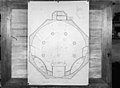 Plattegrond in de verzameling C.H.Peters - Arnhem - 20024826 - RCE.jpg 1,200 × 877; 178 KB
-
 Preekstoel - Arnhem - 20024835 - RCE.jpg 952 × 1,200; 225 KB
-
 Rijnstraat, 6811 Arnhem, Netherlands - panoramio (1).jpg 2,048 × 1,148; 1,001 KB
-

-


_(2181345020).jpg)


.jpg)
_starts_to_get_leafs_in_Arnhem_city_with_the_Koepelchurch_-_panoramio.jpg)
_at_Jansplein_from_1843_in_the_center_of_Arnhem_-_panoramio.jpg)