Category:Korte Linschoten OZ 18, Linschoten
Jump to navigation
Jump to search
| Object location | | View all coordinates using: OpenStreetMap |
|---|
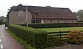
farmhouse in Montfoort, Netherlands  | |||||
| Upload media | |||||
| Instance of | |||||
|---|---|---|---|---|---|
| Location | Linschoten, Utrecht, Netherlands | ||||
| Street address |
| ||||
| Located on street |
| ||||
| Heritage designation |
| ||||
 | |||||
|
This is a category about rijksmonument number 25973
|
| Address |
|
Media in category "Korte Linschoten OZ 18, Linschoten"
The following 2 files are in this category, out of 2 total.
-
 25973-KLOZ18-0123.jpg 2,048 × 1,237; 500 KB
-
 Aanzicht - Linschoten - 20140603 - RCE.jpg 1,200 × 801; 269 KB
