Category:Kreuzigungsgruppe (Stammheim)
Jump to navigation
Jump to search
| Object location | | View all coordinates using: OpenStreetMap |
|---|
This is the category of the Bavarian Baudenkmal (cultural heritage monument) with the ID D-6-79-150-91 (Wikidata)
|
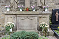
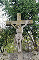
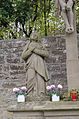
Deutsch: Kreuzigungsgruppe, 1808. Im Friedhof, Kirchweg 19, Stammheim, Gemeinde Kolitzheim, Landkreis Schweinfurt, Unterfranken, Deutschland.
Media in category "Kreuzigungsgruppe (Stammheim)"
The following 5 files are in this category, out of 5 total.
-
 Stammheim, Friedhof, Kreuzigungsgruppe-001.jpg 3,264 × 4,928; 12.94 MB
-
 Stammheim, Friedhof, Kreuzigungsgruppe-002.jpg 4,928 × 3,264; 12.25 MB
-
 Stammheim, Friedhof, Kreuzigungsgruppe-003.jpg 3,264 × 4,928; 13.33 MB
-
 Stammheim, Friedhof, Kreuzigungsgruppe-004.jpg 3,264 × 4,928; 11.72 MB
-
 Stammheim, Friedhof, Kreuzigungsgruppe-005.jpg 3,264 × 4,928; 11.54 MB


