Category:Kumla kyrka, Östergötland
Jump to navigation
Jump to search
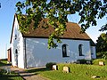
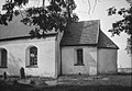
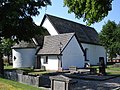
Svenska: Kumla kyrka tillhör Väderstads församling, Folkungabygdens kontrakt, Linköpings stift / Diocese of Linköping
| Object location | | View all coordinates using: OpenStreetMap |
|---|
|
This is a category about an ecclesiastical monument in Sweden, number 21300000004454 (sub-number: 21400000029750) in the RAÄ buildings database.
|
church building in Mjölby Municipality, Sweden    | |||||
| Upload media | |||||
| Instance of | |||||
|---|---|---|---|---|---|
| Location | Mjölby Municipality, Östergötland County, Sweden | ||||
| Diocese | |||||
| Connects with | |||||
| Has use |
| ||||
| Occupant | |||||
| Heritage designation |
| ||||
| Inception |
| ||||
| Different from | |||||
| official website | |||||
 | |||||
Subcategories
This category has the following 2 subcategories, out of 2 total.
Media in category "Kumla kyrka, Östergötland"
The following 5 files are in this category, out of 5 total.
-
 Kumla fr söder 1.jpg 1,175 × 881; 382 KB
-
 Kumla kyrka - KMB - 16001000058946.jpg 780 × 538; 85 KB
-
 Kumla kyrka - KMB - 16001000058964.jpg 537 × 780; 61 KB
-
 Kumla kyrka från luften.jpg 4,256 × 2,832; 2.8 MB
-
 Kumla kyrka, Östergötland.jpg 2,048 × 1,536; 1.35 MB


Categories:
- 12th-century architecture in Mjölby Municipality
- 12th-century churches in Östergötland County
- Churches in the Diocese of Linköping
- Churches in Mjölby Municipality
- Churches in Östergötland
- Listed churches in Mjölby Municipality
- Romanesque stone churches in Östergötland County
- White churches in Sweden
- Kumla District