Category:Kunnersdorf, Erdkeller im Oberdorf
Jump to navigation
Jump to search
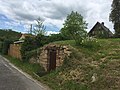
Deutsch: Erdkeller in Schöpstal, Ortsteil Kunnersdorf, bei Oberdorf 31. Erbaut im 19. Jahrhundert. Wirtschaftsgeschichtlich von Bedeutung; Kulturdenkmal
| Object location | | View all coordinates using: OpenStreetMap |
|---|
| (Wikidata) |
| Upload media | |||||
| Instance of | |||||
|---|---|---|---|---|---|
| Location | Schöpstal, Q879194, Görlitz, Saxony, Germany | ||||
| Street address |
| ||||
| Heritage designation | |||||
 | |||||
Media in category "Kunnersdorf, Erdkeller im Oberdorf"
The following 5 files are in this category, out of 5 total.
-
 Kunnersdorf, Erdkeller im Oberdorf (1).jpg 4,032 × 3,024; 3.37 MB
-
 Kunnersdorf, Erdkeller im Oberdorf (2).jpg 4,032 × 3,024; 4.35 MB
-
 Kunnersdorf, Erdkeller im Oberdorf (3).jpg 3,024 × 4,032; 3.68 MB
-
 Kunnersdorf, Erdkeller im Oberdorf (4).jpg 4,032 × 3,024; 4.53 MB
-
 Kunnersdorf, Erdkeller im Oberdorf (5).jpg 4,032 × 3,024; 3.79 MB
.jpg)
.jpg)
.jpg)
.jpg)
.jpg)