Category:Königsteiner Straße 20, Pirna
Jump to navigation
Jump to search
| Object location | | View all coordinates using: OpenStreetMap |
|---|
| (Wikidata) |
| Upload media | |||||
| Instance of | |||||
|---|---|---|---|---|---|
| Location | Pirna, Sächsische Schweiz-Osterzgebirge, Saxony, Germany | ||||
| Heritage designation | |||||
 | |||||
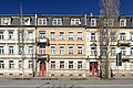
Deutsch: Mietshaus in geschlossener Bebauung, 1890er Jahre (Mietshaus); baugeschichtlich und städtebaulich von Bedeutung, ein Gründerzeithaus (Klinkerfassade) mit straßenbildprägenden Balkonen
Media in category "Königsteiner Straße 20, Pirna"
The following 4 files are in this category, out of 4 total.
-
 Koenigsteiner Strasse 20 Zentralperspektive 2022.jpg 6,016 × 4,000; 13.95 MB
-
 Königsteiner Straße 19-21 Pirna.JPG 2,560 × 1,920; 2.91 MB
-
 Königsteiner Straße 20 Pirna.JPG 2,560 × 1,920; 2.86 MB
-
 Pirna, Germany - panoramio (24).jpg 4,896 × 3,672; 5.6 MB


.jpg)