Category:Löberstraße (Erfurt)
Jump to navigation
Jump to search
| Object location | | View all coordinates using: OpenStreetMap |
|---|
street in Erfurt, Thuringia, Germany | |||||
| Upload media | |||||
| Instance of | |||||
|---|---|---|---|---|---|
| Location | Erfurt, Thuringia, Germany | ||||
 | |||||
Subcategories
This category has the following 2 subcategories, out of 2 total.
- Löberstraße 14 (Erfurt) (2 F)
- Löberstraße 19 (Erfurt) (5 F)
Media in category "Löberstraße (Erfurt)"
The following 13 files are in this category, out of 13 total.
-
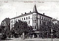
 Alte Thomaskirche 1899.png 2,559 × 3,162; 6.48 MB
-
 Kaffeetrichter Erfurt.JPG 715 × 500; 181 KB
-
 Kaffeetrichter.JPG 1,600 × 1,200; 408 KB
-
 Erfurt AlteThomaskirche1902.jpg 768 × 1,158; 410 KB
-
 Erfurt Opel Rekord 1.jpg 3,648 × 2,736; 3.64 MB
-
 Erfurt Opel Rekord 2.jpg 3,648 × 2,736; 3.12 MB
-
 Erfurt Opel Rekord 3.jpg 3,648 × 2,736; 3.22 MB
-
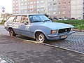 Erfurt Opel Rekord 4.jpg 3,648 × 2,736; 3.03 MB
-
 Erfurt Weimar 18 (3).jpg 3,024 × 3,060; 689 KB
-
 Old Thomas church of Erfurt 2.JPG 3,072 × 2,304; 1.9 MB
-
 Löberstraße 19 Erfurt.jpg 2,816 × 1,880; 1.03 MB
-
 Juri-Gagarin-Ring 24 Erfurt 20211003 0091.jpg 3,382 × 5,083; 17.89 MB
-
 Old Thomas church of Erfurt 1.JPG 2,304 × 3,072; 1.86 MB


.jpg)


