Category:La Farga (Anglès)
Jump to navigation
Jump to search
| Object location | | View all coordinates using: OpenStreetMap |
|---|
 | |||||
| Upload media | |||||
| Instance of | |||||
|---|---|---|---|---|---|
| Location | Anglès, Selva, Comarques Gironines, Catalonia | ||||
| Architectural style | |||||
| Heritage designation |
| ||||
| Elevation above sea level |
| ||||
 | |||||
Català: La Farga (Anglès)
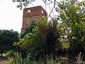
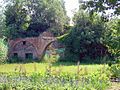
This is a category about a building listed in the Catalan heritage register as Bé Cultural d'Interès Local (BCIL) under the reference IPA-32453. |
Media in category "La Farga (Anglès)"
The following 6 files are in this category, out of 6 total.
-
 La Farga d'Anglès 1.jpg 5,152 × 3,864; 7.6 MB
-
 La Farga d'Anglès 2.jpg 5,152 × 3,864; 7.79 MB
-
 La Farga d'Anglès 3.jpg 5,152 × 3,864; 7.13 MB
-
 La Farga d'Anglès 4.jpg 5,152 × 3,864; 6.39 MB
-
 La Farga d'Anglès 5.jpg 5,152 × 3,864; 7.96 MB
-
 La Farga d'Anglès 6.jpg 5,152 × 3,864; 6.3 MB


